Proposal for Swarm DISC ITT 1.1
Multi-approach gravity �eld models
from Swarm GPS data
Contents
List of Figures
List of Tables
1 Executive summary
Although the knowledge of the gravity of the Earth has improved considerably with the
CHallenging Mini-Satellite Payload (CHAMP) (Reigber2002; Reigber, Schwintzer
and Luehr 1996), Gravity Recovery And Climate Experiment (GRACE) (Tapley,
Reigber and Melbourne 1996; Tapley et al. 2004) and Gravity �eld and steady-state
Ocean Circulation Explorer (GOCE) (Balmino et al. 1999; Floberghagen et al. 2011)
satellite missions, the geophysical community has identi�ed the need for the
continued monitoring of its time-variable component with the purpose of estimating
the hydrological and glaciological yearly cycles and long-term trends. Currently,
the GRACE satellites are the sole provider of this data and the GRACE Follow On
(GRACE-FO) (Sheard et al. 2012; Larkin 2012; Flechtner et al. 2014) mission aims to take
over this role after December 2017. The current proposal aims at providing the
high-quality gravity �eld models from Swarm data that constitute an alternative
source of gravimetric data, which could help alleviate the consequences of the
potential gap between GRACE and GRACE-FO, as well as the short gaps in the
existing GRACE data. Independently on the existence of gravimetric data from
dedicated satellite missions, the gravity �eld models derived from Swarm GPS
data constitute an independent source of information about Earth's gravity �eld,
e.g. for monitoring large mass transport processes (Teixeira Encarnação et al.,
2017).
Recently, the geodetic community has realised that the combination of the di�erent
gravity �eld solutions is superior to any individual model, as demonstrated for
GRACE by Jean, Meyer and Jäggi (2015a) and Jean, Meyer and Jäggi (2015b), and for
Swarm by Teixeira da Encarnação et al. (2016). In response to the call for Swarm
gravity �eld models issue by the Data, Innovation and Science Cluster (DISC)
consortium, we intend to exploit of this fact and deliver to highest quality gravity �eld
models, resulting from the combination of 4 di�erent gravity �eld estimation
approaches.
Additionally, we intend to evaluate the added value of Kinematic Baselines (KBs) in the
quality of the combined gravity �eld model. For that purpose, 2 di�erent KBs solutions will
be studied within the context of the project. The choice of which KB solution (if any) is used
for the production of the models of the various institutes is left to the respective
responsible scientist. To answer the Statement of Work (SoW), we will also determine the
bene�t of two di�erent models of non-gravitational forces and the measured
non-gravitational accelerations from Swarm-C to the quality of the gravity �eld
models.
The strong points of our proposal are i) the statistically-optimal combination of models
derived with 4 di�erent gravity estimation strategies, each producing state-of-the-art
Swarm gravity �eld models, ii) the use of 3 independently-developed Precise Orbit
Determination (POD) software packages to estimate the Kinematic Orbits (KOs), iii) the
analysis of the improvement resulting from using accelerometer measurements from
Swarm-C or 2 di�erent non-gravitational force models and iv) the study of the added value
to the quality of the gravity �eld models when considering the KBs computed with 2
di�erent strategies.
A prerequisite for the proposed objectives is the involvement of numerous institutions.
This has the unfortunate disadvantage of diluting the funding and limiting considerably the
time devoted to project activities. In spite of this, we have constructed a WP arrangement
that minimizes overhead costs and maximizes independent progress, in order to fully take
advantage of the available resources.
1.1 Project Structure
The work plan considered in this proposal is based on the tasks speci�ed in the
SoW:
-
Task 1:
- Swarm Gravity Field Processor;
-
Task 2:
- Swarm Data Pre-processing;
-
Task 3:
- Validation of Swarm Gravity Field Processor;
-
Task 4:
- Swarm Gravity Field Models;
-
Task 5:
- Final presentation.
Each task is addressed with the following WPs:
-
WP100:
- Documentation of the Swarm Gravity Field Processors (Task 1);
-
WP200:
- Swarm data pre-processing, KBs and accelerometer data (Task 2);
-
WP300:
- Swarm models validation (Task 3);
-
WP400:
- Swarm models processing (Task 4);
-
WP500:
- Publication and presentation of project results (Task 5);
At the end of the project the following main results are expected:
- Detailed descriptions of data processing algorithms;
- Study of the added value of kinematic baselines and accelerometer data or
models in the quality of the Swarm gravity �eld models;
- Production and dissemination of state-of-the-art gravity �eld models, as the
result of the combination of 4 di�erent approaches;
- Publication and presentation of the main results;
- Recommendations for future development of GNSS-driven gravity �eld
models.
The Technical Proposal is provided in 2 of this document, in which we show our
understanding of the project requirements and describe the methodology we propose to
meet those requirements.
The Implementation Proposal can be found in 3, describing the WPs, their distribution
amongst the study team, the schedule, the list of deliverables and the preliminary risk
assessment.
4 contains the Management Proposal, where details on the study team are given, their
roles in the project are presented, the organisation and management of the project is
described and a few adjustments on the project requirements (Section 5 of the SoW) are
proposed.
The Financial Proposal is shown in ??, where the Price Quotation is given, the
sub-contracting plan is presented, the inclusion of OSU (operating from a non-ESA
member state, USA) is motivated (in ??) and small modi�cation to the Payment Plan is
proposed.
Finally, the Contractual Proposal is covered in ??, the price summary is present in ??, the
compliance matrix is �lled and signed in ??, the Curricula Vit� (CVs) of the team members
are given in ?? and the Procedures Speci�cations and Standards (PSS) A2 and A8 forms are
in ??.
The electronic version of this document contains unmarked links in table (e.g. 1), �gure
(e.g. 1), section (e.g. 1) and literature references (e.g. Allende-Alba et al. (2017)), as well as in
acronyms (e.g. GRACE), URLs (e.g. www.aiub.unibe.ch) and WP numbers (e.g.
WP100).
2 Technical Proposal
The Technical Proposal provides the team's interpretation of the Statement of Work. It does
this by o�ering a detailed description of the technical work to be performed, and the
proposed approach in taking on this work.
2.1 Introduction
The GPS instruments on-board the three Earth's Magnetic Field and Environment Explorer
(Swarm) satellites collects highly accurate hl-SST data (IJssel et al., 2015; IJssel,
Forte and Montenbruck, 2016), with su�cient quality to measure the monthly
gravity �eld model at basin-wide spatial scales (Teixeira da Encarnação et al.,
2016).
2.2 Proposed concept
We propose to produce the state-of-the-art models that are the results of the
statistically-optimal combination of 4 gravity �eld models produced with di�erent gravity
�eld inversion strategies. As a result, the combined model bene�ts from the strong aspects
of every approach and are consistently better than any individual solution, as
demonstrated for GRACE (Jean, Meyer and Jäggi, 2015b; Jean, Meyer and Jäggi, 2015a),
Swarm (Teixeira da Encarnação et al., 2016). In this proposal, the term individual solution
refers to the gravity �eld models produced with one of the 4 approaches described in 2.3.
In contrast, the combined model refers to the result of the combination of all individual
solutions.
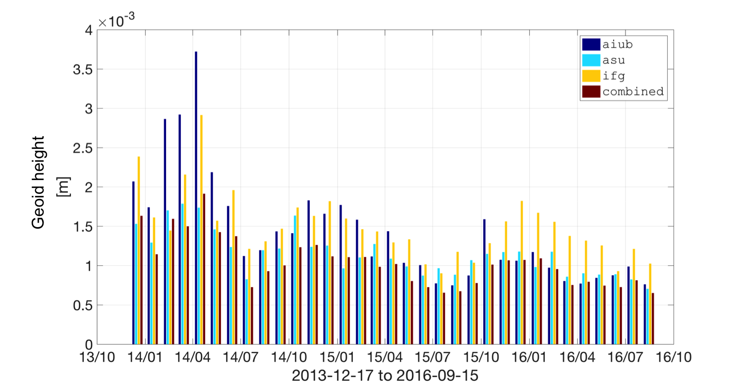
In 1, the superior quality of the combined models is clearly illustrated by the
smaller amplitude of the combined model (in dark red), relative to the individual
solutions.
The combination strategy exploited to produce 1 was simple arithmetic averaging,
which is sub-optimal. The proper combination of the individual models considering the
error variance-covariance is expected to increase the quality of the combined
model.
2.3 Design references
2.3.1 Non-gravitational accelerations
To answer Task 2 of the SoW, the analysis of 3 di�erent types of non-gravitational
accelerations will be conducted. Two models are going to be considered (one implemented
by TU Delft and the other by ASU) as well as the accelerometer measurements collected by
Swarm-C.
Modelled non-gravitational accelerations produced at TU Delft
Modelled non-gravitational acceleration time series for all three Swarm satellites are
already routinely produced at TU Delft as part of the Swarm ESL Level 2 (L2) processing
activities (Siemes2016). These time series are available as an intermediate L2 product
(ACCx_FMi2). Currently, the aerodynamic forces are based on the satellite panellised
geometry speci�cation received from ESA, but an upgrade will be made to use normalised
force coe�cients obtained from the SPARTA free-molecular �ow analysis software (Gallis
et al., 2014), based on a highly detailed Computer-Aided Design (CAD) geometry
model.
The empirical thermosphere density model that is used in the Swarm L2 ACCx_FMi2
non-gravitational acceleration models (currently NRLMSISE-00) is known to contain
time-variable biases related to changes in solar activity level, which deteriorates the quality
of the acceleration data. Such errors can be signi�cantly reduced by replacing the solar
activity input to the density model (F10.7 for NRLMSISE-00) by values estimated from the
Swarm L2 DNSxPOD_2 product. If this correction is performed only for the part of
the bias that changes slowly, over days and longer periods, it will eliminate the
solar-activity-dependent biases in the non-gravitational acceleration time series to a very
large extent, while keeping the in�uence of the gravity �eld models used in the ACCxPOD
processing to a minimum.
Modelled non-gravitational accelerations produced at ASU
For processing the satellite orbital data, the coordinate transformations and the generation
of modelled forces, on which the creation of the modelled non-gravitational accelerations
of each Swarm satellite is based, the ASU home-made orbital propagator NUMINTSAT is
used (Bezděk et al., 2009). In order to compute the non-gravitational forces, ESA provides
scienti�c users with the physical properties of the satellite, its mass, cross-section in a
speci�c direction, radiation properties of the satellite's surface and a macromodel
approximately characterizing the shape of the Swarm satellites. When representing the
force due to atmospheric drag, we paid special attention to quantities usually having most
uncertainty in their speci�c values. For neutral atmospheric density, we made use of the
NRLMSISE-00 model. To have a realistic drag coe�cient, for each satellite we estimated it
by means of the long-term change in orbital elements. The details of our approach
can be found in references, e.g. (Bezděk, 2010; Bezděk et al., 2014; Bezděk et al.,
2016).
Measured non-gravitational accelerations
The measured non-gravitational accelerations produced in ASU are based mainly on the
Level 1A (L1A) product ACCxSCI_1A, which provide the observations from an
accelerometer aboard each Swarm satellite. A rather strong in�uence of temperature on
Swarm accelerometer data has been evident since the mission start; on the other hand, it
was demonstrated that the physical non-gravitational signal was also recorded, most
clearly in the along-track accelerometer component of Swarm-C (Siemes2016; Bezděk,
Sebera and Klokočník, 2014). The modelled non-gravitational accelerations look like a
smoothed version of the accelerometer observations, but the accelerometer data generally
supersede the modelled non-gravitational accelerations by providing more detailed
information on high-frequency contents of the external perturbations. Besides, the
accelerometer measurements show the spikes corresponding to activating the
satellite thrusters and other satellite-related phenomena, which are not present in
the non-gravitational models. To reduce the high temperature dependence, we
apply a method of linear temperature correction; we presented its successful
use on several Swarm Cal/Val meetings and recently in a publication (Bezděk
et al., 2016). So far, and in accordance with results presented by the ESA team
(Siemes2016), acceptable results have been obtained only for the accelerometer data in
the along-track component of Swarm-C. In this project, we will investigate the
possibility to calibrate the other two components of Swarm-C (cross-track and
radial) and their possible use for the gravity �eld inversion. Thus, the modelled
non-gravitational accelerations from ASU or TU Delft will replace the gaps in Swarm-C
accelerometer data and represent the non-gravitational accelerations in Swarm A and
B.
2.3.2 Kinematic Orbits
| Institute | Location | Software | Reference |
| AIUB | Bern,
Switzerland | Bernese! (Dach2015) | Jäggi et al. (2016) |
| IfG | Graz, Austria | Gravity Recovery Object Oriented
Programming System (GROOPS)
(in-house development) | Zehentner and
Mayer-Gürr
(2016) |
| TUD | Delft,
Netherlands | GPS High precision Orbit
determination Software Tool
(GHOST) (Helleputte 2004;
Wermuth, Montenbruck and
Helleputte 2010) | IJssel et al. (2015) |
| |
Table 1: Overview of the Kinematic Orbits and the software packages used to
estimate them
Kinematic Orbits produced at TU Delft
Kinematic orbits for the Swarm satellites are routinely computed by TU Delft in the
framework of the Swarm ESL L2 processing. The detailed processing strategy that is used to
compute these orbits is described in (IJssel et al., 2015). Using independent Satellite Laser
Ranging (SLR) validation it is shown that for the �rst year of mission operations these
kinematic orbits have an accuracy of about 4-5 cm.
It is also shown that the Swarm GPS observations are noticeably a�ected by ionospheric
scintillation, which leads to slightly larger kinematic orbit errors close to the geomagnetic
poles and along the geomagnetic equator. Meanwhile several GPS receiver tracking loop
modi�cations have been implemented to increase the receiver robustness for ionospheric
scintillation (IJssel, Forte and Montenbruck, 2016). In addition, going from solar maximum
conditions at the start of the mission to lower solar activity in the current solar cycle has
also reduced the occurrence and intensity of ionospheric scintillation. Therefore it is
expected that the recent kinematic Swarm orbits have slightly improved accuracy
levels.
As kinematic orbits do not involve any a priori assumptions on the spacecraft dynamics,
they are well suited for the recovery of the Earth's gravity �eld. For best performance the
covariance information should also be taken into account in the gravity �eld recovery. For
this project, therefore also covariance information of the kinematic orbits will be
provided.
Kinematic Orbits produced at AIUB
The AIUB generates both kinematic and reduced-dynamic Low-Earth Orbit (LEO) orbits.
The method to generate these types of orbits with the Bernese GNSS software (Bernese)
(Dach2015) has been successfully used for POD of many di�erent Low-Earth Orbiters, e.g.,
CHAMP, GRACE, Jason-2, MetOp-A, GOCE, TerraSAR-X and TanDEM-X, the Swarm and the
Sentinel satellites (Jäggi, Hugentobler and Beutler, 2006; Jäggi et al., 2007; Bock et al., 2011;
Jäggi et al., 2012; Jäggi et al., 2016), and is described in detail in Jäggi, Hugentobler
and Beutler (2006). The standard orbit determination procedures are based on a
batch least-squares approach using zero-di�erence ionosphere-free GPS carrier
phase data. They were operationally used for the Precise Science Orbit (PSO)
determination in the frame of the GOCE High-Level Processing Facility (HPF) (Bock et al.,
2014) and are used for i) an independent assessment of the Swarm data in the
frame of the Swarm Quality Working Group (QWG) (Dahle, Arnold and Jäggi, 2017)
and ii) an independent validation of the o�cial Sentinel orbit products in the
frame of the Sentinel POD QWG of the Copernicus POD Service (Peter et al., 2017).
The kinematic LEO positions are purely geometrical solutions of a Precise Point
Positioning (PPP) as implemented in the Bernese! and are derived together with
epoch-wise covariance information from the GPS phase observations and attitude data
collected on-board the LEO satellites. Kinematic positions from CHAMP, GOCE, and
Swarm were used to recover the long wavelength part of the Earth's gravity �eld and
to study the capability of GPS hl-SST tracking to recover time variations of the
Earths gravity �eld (Weigelt et al., 2013; Jäggi et al., 2016; Dahle, Arnold and Jäggi,
2017).
Kinematic Orbits produced at IfG
KOs are produced at the IfG applying the in-house developed raw observation approach
(Zehentner and Mayer-Gürr, 2016; Zehentner, 2016). The method is implemented within
the software package Gravity Recovery Object Oriented Programming System (GROOPS)
developed at the IfG. The raw observation approach was �rst used for kinematic orbit
estimation of GRACE and GOCE (Zehentner and Mayer-Gürr, 2014) and later applied to
various satellite mission like CHAMP, Constellation Observing System for Meteorology,
Ionosphere and Climate (COSMIC), C/NOFS, TerraSAR-X, TanDEM-X, Meteorological
Operational satellite programme (MetOp), Swarm, Jason and the Sentinel satellites
(Zehentner, 2016). All of them were used to retrieve static and time variable gravity �eld
information. The approach is based on the concept of directly using all GNSS
observations of any kind in a common least-squares adjustment. Meaning code and
phase observations on all available frequencies are used without forming linear
combinations. Thus in�uences on the observables must be known in advance or set up as
parameter in the estimation. For example the ionospheric in�uence is set up as
slant total electron content parameter for each tracked GNSS satellite in each
epoch. On the one hand this leads to a high number of parameters but on the
other hand gives the possibility to access and analyse each of these parameters
individually. A unique aspect of the kinematic orbit processing at the IfG is the fact that
azimuth and nadir dependent phase and code antenna centre variations are used
routinely for receivers and transmitters. Furthermore an important aspect is a realistic
observation weighting. This is achieved by generating and using azimuth and nadir
dependent accuracy information for each individual receiver by analysing observation
residuals.
2.3.3 Kinematic Baseline
Kinematic Baselines produced at TU Delft
The KBs for the Swarm A and C pair of satellites will be computed with the Multiple
satellites Orbit Determination using Kalman �ltering (MODK) tool, which is an add-on tool
of the GHOST software that is developed and maintained by Deutsches Zentrum für Luft-
und Raumfahrt (DLR) German Space Operations Centre (GSOC), with support by the
TU Delft (Montenbruck et al., 2007; Barneveld, 2012).
The MODK relies on an iterative Kalman �ltering procedure, where carrier-phase
ambiguities are resolved as much as possible using a reduced-dynamic orbit determination
technique. MODK has the capability to derive the KBs after the carrier-phase ambiguity
�xing. The MODK tool has been enhanced with the possibility to use frequency dependent
antenna correction maps for both carrier-phase and code observations (Mao et al., 2017).
For this project, the MODK tool will be extended with the capability to provide covariance
information for the KBs.
Kinematic Baselines produced at AIUB
AIUB has gained experience in precise baseline determination from the analysis of data
from the GRACE, TanDEM-X, and Swarm missions using di�erential GPS with ambiguity
�xing (Jäggi et al., 2007; Jäggi et al., 2012; Jäggi et al., 2016). Precise baseline determination
from Swarm is challenged by ionospheric disturbances and half-cycle ambiguities which
are present in the GPS data. Whereas the impact of the ionospheric disturbances could be
reduced thanks to several updates performed in the tracking loop settings (Dahle, Arnold
and Jäggi, 2017), the latter could recently by circumvented as described by (Allende-Alba
et al., 2017). The AIUB is thus in an excellent position to exploit precise Swarm baselines
also for gravity �eld recovery. First gravity �eld recovery experiments using real
data from GPS-based precise GRACE baselines were already performed by Jäggi
et al. (2009), who showed in particular that a gain of about a factor of ten in the
accuracy of the space baseline (using di�erential GPS with ambiguity resolution
techniques) with respect to the corresponding precise point positioning results is
not accompanied by a corresponding gain (of the same factor of ten) in gravity
�eld determination. This at �rst sight puzzling result is caused by the fact that
di�erential GPS with ambiguity resolution substantially reduces (actually by this
factor of ten) the errors of long period (10-20 minutes) in the baseline, but not the
noise of subsequent position di�erences. Simulations related to Swarm gravity
�eld recovery are often based on the above mentioned seemingly plausible, but
erroneous assumptions concerning noise reduction (e.g., Wang, Gerlach and Rummel
(2012)). Nevertheless, Jäggi et al. (2009) also concluded that the use of GPS-derived
inter-satellite kinematic baselines is worth to be further studied for gravity �eld
determination because of the possible reduction of systematic errors in the GPS
results by forming observation di�erences. Better tools are meanwhile available at
AIUB for GRACE K-Band data analysis and will be adapted in the frame of this
project to exploit Swarm precise baseline solutions for gravity �eld recovery by
treating GPS-derived inter-satellite vectors in close analogy to GRACE K-Band
measurements.
2.3.4 Gravity �eld inversion approaches
The individual solutions are produced independently by di�erent institutes, following the
choices, assumptions and input KOs established by the corresponding responsible
scientist. It may be the case that (e.g.) a particular type of KO produces much better gravity
�eld models in one gravity �eld inversion approach but that is not the case in a di�erent
approach. The same can be said about empirical accelerations, decorrelation strategies,
etc. This variety in approaches, assumptions and input data considered in the production
of individual solutions is what confers robustness to the combined model and is the
strongest asset in our proposal.
| Inst. | Location | Approach | Reference |
| AIUB | Bern,
Switzerland | Celestial Mechanics Approach
(Beutler et al., 2010) | Jäggi et al. (2016) |
| ASU | Prague,
Czech Rep. | Decorrelated Acceleration Approach
(Bezděk et al., 2014) | Bezděk et al.
(2016) |
| IfG | Graz,
Austria | Short-Arcs Approach
(Mayer-Gürr, 2006) | Zehentner and
Mayer-Gürr
(2016) |
| OSU | Columbus,
USA | Energy Balance Approach
(Shang et al., 2015) | Guo et al. (2015) |
| |
Table 2: Overview of the gravity �eld estimation approaches
The next sections brie�y describe the 4 gravity �eld determination approaches
considered in the production of the individual gravity �eld models.
The Celestial Mechanics Approach
The variational equations approach (Reigber, 1989), of which the Celestial Mechanics
Approach (CMA) (Beutler et al. 2010) is a variant of, connects the measured distances from
the GPS satellites (or other GNSS measurements, SLR observations, KO data or ll-SST
tracking data) and a set of unknown parameters which may include Stokes coe�cients,
initial state vectors, empirical accelerations, drag coe�cients, instrument calibration
parameters (e.g. accelerometer) and other parameters which play a role in the
dynamic equations of motion of the satellite. This is accomplished by linearising the
mathematical model describing the motion of the satellite when considering a
priori reference gravity �eld model and remaining a priori assumptions (such
analytically-derived initial state vectors, initial guess for drag coe�cients, calibration
parameters provided by instruments manufacturer, etc.). The linearisation is performed
(usually numerically) around the reference model response, i.e. the values of the unknown
parameters computed from the reference model when considering the a priori
assumptions.
The CMA is exploited by Astronomical Institute of the University of Bern (AIUB).
The Decorrelated Acceleration Approach
The so-called acceleration approach exploits Newton's equation of motion directly
(Rummel, 1979) and is the foundation for the Decorrelated Acceleration Approach (DAA)
(Bezděk et al. 2014; Bezděk et al. 2016). The method connects the double-di�erentiated
orbital positions to the external forces acting on the satellite. This approach i) avoids
numerical integration operations characteristic of other approaches, and ii) computes the
geopotential harmonic coe�cients from a linear (not linearised) system of equations. The
observations are �rst transformed to the inertial reference frame before di�erentiation to
avoid the computation of �ctitious accelerations. The di�erentiation of noisy observations
leads to the ampli�cation of the high-frequency noise. However, it is possible to handle the
high-frequency noise with a decorrelation procedure, so far for this purpose a �tted
autoregressive process has been used.
The DAA method has been developed by the ASU and applied successfully
to Swarm kinematic orbits to produce the monthly gravity �elds (Bezděk et al.,
2016).
The Short-Arcs Approach
The short arc integral approach is described in detail by Mayer-Gürr (2006). It has been
used to generate several global gravity �eld models based on CHAMP and GRACE data,
namely the ITG-GRACE (Mayer-Gürr, 2007; Mayer-guerr et al., 2010), the ITG-CHAMP (Ilk,
Mayer-Gürr and Feuchtinger, 2004) models as well as the latest models ITSG-GRACE2014
(Mayer-Gürr et al. 2014) and ITSG-GRACE2016 (Klinger2016). The method is
based on the solution of the Newton's equation of motion by double-integration
and formulation as a boundary value problem. The unknown boundary values
(start and end position of each arc) are estimated in a least-squares adjustment
along with additional parameters which may include the Stokes coe�cients and
empirical parameters for non-conservative forces or calibration parameters, like
accelerometer biases or drifts. As observations hl-SST data as well as ll-SST data may be
included. The name short arc refers to the fact that observation data is usually
split into arcs with a length of 20 to 60 minutes. The normal equations are set up
for each arc individually and later combined on the level of normal equations.
Variance component estimation is used to de�ne the relative weighting between the
arcs.
The Short-Arcs Approach (SAA) is used at Institute of Geodesy Graz (IfG) to produce
gravity �eld models.
The Energy Balance Approach
The Energy Balance Approach (EBA), also known as energy integral approach, is based on
the energy conservation principle (O'Keefe, 1957; Jekeli, 1999; Gerlach, 2003; Gerlach et al.,
2003). This principle states that the variations in kinetic energy of the satellite are equal to
the work done by the all forces directed parallel to the velocity vector. Conservative forces,
such as gravitational accelerations, can be related to their potential, providing a linear
relationship to the unknown spherical harmonics coe�cients. The formulation and
applications of earlier EBA methods developed for CHAMP and GRACE gravity �eld
inversion include Han et al. (2005) and Han, Shum and Jekeli (2006). An improved EBA
formulation enabled a 4 order of magnitude improvement in precision of the GRACE KBR
data-derived disturbance potential observables (Zeng2015a; Guo et al., 2015; Shang et al.,
2015), as compared to prior studies, e.g., Jekeli (1999). The derived disturbance potential
observables, when used in temporal gravity �eld inversion have achieved similar level of
accuracy as the o�cial GRACE L2 products Shang et al. (2015). We will revise
the EBA formulation here for Swarm temporal gravity �eld estimation for this
project.
The EBA is exploited by Ohio State University (OSU).
2.4 Proposed product validation and quality assurance strategy
The quality assurance of all intermediate products is solely the responsibility of the
scientist responsible for the corresponding WP, see 3.2. He/she will be responsible for
conducting internally-de�ned measures and veri�cation procedure to be sure that the data
is of the highest quality, stored in in the de�ned format and uploaded error-free to the
exchange server.
In what regards the data to be disseminated to Payload Data Ground Segment (PDGS),
WP300 (Swarm models validation) will ensure that the combined models have the expected
residuals relative to GRACE and, in those months when GRACE models are not available,
they describe basin-wide mass variations with the expected magnitude and with a valid
geophysical meaning. This veri�cation will be documented in TN-03 (deliverable to
WP300).
In its most basic form, the validation quanti�es in aggregate statistics, such as RMS, the
geoid height di�erences relative to GRACE, at those wavelengths that Swarm is sensitive to.
On example of this quanti�cation is shown in 1.
In the SoW, no requirements were de�ned regarding the quality of the Swarm gravity
�eld models. We will however assess and demonstrate the quality of the products in several
ways, namely those used by Teixeira da Encarnação et al. (2016), Figures 1-10 and Table
3.
3 Implementation Proposal
This section gives some details on the proposed implementation strategy. Due to the
particularly limited funding in comparison to the size of the project team and the
number of institutes involved, the project is designed to be carried out as much
independently as possible. 4.3.1 and 4.3.3 describe additional details regarding this
set-up.
The WPs are intended to be exclusively assigned to one particular sub-contractor,
in order to minimize the management burden during the project activities. It is
intended that from the Kick O� (K/O) date, all partners are fully aware of their
tasks, so that their e�orts are directed towards processing data and the analysis
required in Tasks 2, 3 and 5 of the SoW. In this way, the work can be carried out
independently, only being assembled together at a later stage and within a parent
WP given the inputs
from sub-WPs .
Evidently, the independence of the work in WPs does not preclude the necessary
management activities and progress monitoring, at the discretion of the parent WP leader,
institute team leader of project leader (more on this in 4.3.1 and 4.6).
In setting up the project in this streamlined fashion, we intend to reduce the workload
of all partners and, as a consequence, reduce the costs in order to maximize the time
dedicated to the project activities. Additionally, the largest share of management e�orts is
put in this document, so that there is minimal need to spend time in those activities during
the project execution. The disadvantage of this set-up is that there are numerous WPs, but
given the numerous partners and intermediate products, that would probably be the case
in any other WP arrangement.
3.1 Work Breakdown Structure
3 lists the WPs and the time devoted by each partner.
| |
| |
|
| |
| Reference | Name | TU Delft | AIUB | ASU | IfG | OSU |
| WP100 | Documentation of the Swarm Gravity Field
Processors | 20 | 0 | 0 | 0 | 0 |
| WP200 | Swarm data pre-processing, KBs and
accelerometer data | 0 | 0 | 264 | 0 | 0 |
| WP210 | GPS data pre-processing algorithms | 0 | 40 | 0 | 0 | 0 |
| WP220 | Trade-o� between Swarm accelerometer
data and non-gravitational models | 0 | 0 | 200 | 0 | 0 |
| WP221 | Modelled non-gravitational accelerations
(ASU) | 0 | 0 | 200 | 0 | 0 |
| WP222 | Modelled non-gravitational accelerations
(TU Delft) | 20 | 0 | 0 | 0 | 0 |
| WP223 | Measured non-gravitational accelerations | 0 | 0 | 200 | 0 | 0 |
| WP230 | KBs for gravity �eld estimation | 0 | 0 | 0 | 20 | 0 |
| WP231 | KBs derived from Swarm GPS data (AIUB) | 0 | 30 | 0 | 0 | 0 |
| WP232 | KBs derived from Swarm GPS data
(TU Delft) | 30 | 0 | 0 | 0 | 0 |
| WP300 | Swarm models validation | 40 | 0 | 0 | 0 | 0 |
| WP400 | Swarm models processing | 0 | 0 | 0 | 92 | 0 |
| WP411 | KOs (AIUB) | 0 | 60 | 0 | 0 | 0 |
| WP412 | KOs (IfG) | 0 | 0 | 0 | 80 | 0 |
| WP413 | KOs (TU Delft) | 20 | 0 | 0 | 0 | 0 |
| WP421 | Swarm gravity �elds (AIUB) | 0 | 60 | 0 | 0 | 0 |
| WP422 | Swarm gravity �elds (IfG) | 0 | 0 | 0 | 60 | 0 |
| WP423 | Swarm gravity �elds (ASU) | 0 | 0 | 250 | 0 | 0 |
| WP424 | Swarm gravity �elds (OSU) | 0 | 0 | 0 | 0 | 50 |
| WP430 | Combined Swarm gravity �elds models | 0 | 35 | 0 | 0 | 0 |
| WP440 | Data transfer | 20 | 0 | 0 | 0 | 0 |
| WP450 | User support | 10 | 0 | 0 | 0 | 0 |
| WP500 | Publication and presentation of project
results | 48 | 0 | 0 | 0 | 0 |
| - | Total | 208 | 225 | 1114 | 252 | 50 |
| |
Table 3: Work breakdown structure
3.2 Work Package Description
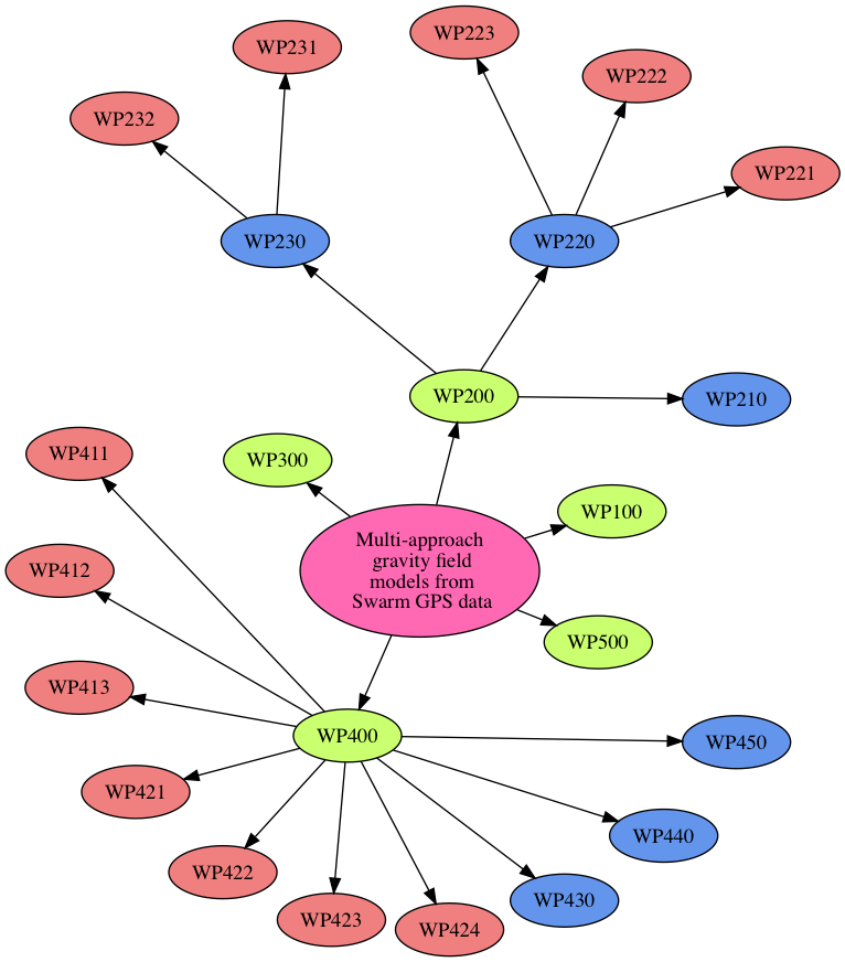
The work to be carried out in each WP is described in the following sections. Refer to 2 to
better visualise the relation between the WPs. Note that there is no WP410 nor WP420
because the activities allocated to those WPs, i.e. the production of KOs and the individual
gravity �eld solutions, respectively, is to be conducted completely independently by the
various institutes.
WP100: Documentation of the Swarm Gravity Field Processors
| Start event: | K/O + 0 months |
| End event: | K/O + 1 months |
| E�ort: | 20 hours |
| Manager: | João Encarnação (TU Delft ) |
| Inputs: | Software documentation, European Gravity Service for
Improved Emergency Management (EGSIEM) standards |
| Outputs: | TN-01 |
| |
The objective of WP100 is to address Task 1 of the SoW. Given the numerous gravity
�eld inversion strategies within the project, the deliverable TN-01 will provide
the description of their most important aspects, both common and divergent.
This document will brie�y describe the EGSIEM standards, since those are the
standards considered in our software (and not GRACE and GRACE-FO standards, as
suggested in the SoW), and ensure that all processors are in agreement with those
standards.
Additionally, there is no need to adapt the existing processors to the Swarm data (as
suggested in the SoW), since all processors are already producing gravity �eld models from
those data.
WP200: Swarm data pre-processing, KBs and accelerometer data
| Start event: | K/O + 1 months |
| End event: | K/O + 6 months |
| E�ort: | 264 hours |
| Manager: | Aleš Bezděk (ASU ) |
| Inputs: | TN-02.1, TN-02.2 and TN-02.3 |
| Outputs: | TN-02 |
| |
The objective of WP200 is to address Task 2 of the SoW. This WP is divided into
sub-WPs (see the next sections) representing individual tasks needed in order to
produce the deliverable TN-02. The work to be carried out speci�cally in WP200 is
to:
- ingest the deliverables from the sub-WPs, speci�cally TN-02.1, TN-02.2 and
TN-02.3 (for this reason, this WP extends one month later than the latter than
TN-02.2 and TN-02.3);
- compile TN-02, speci�cally:
- recommending the inclusion of measured or modelled non-gravitational
accelerations in the production of the gravity �eld models (WP421 to
WP424);
- concluding on the added value of scalar KBs to the quality of the gravity
�eld solutions, as a general guideline for future studies.
The end of this WP marks the Mid-Term Review (MTR), when all partners will agre
on type of non-gravitational accelerations to be considered by all gravity �eld
processors.
Finally, this WP includes the workload required to manage the progress of the activities
in the sub-WPs.
WP210: GPS data pre-processing algorithms
| Start event: | K/O + 1 months |
| End event: | K/O + 2 months |
| E�ort: | 40 hours |
| Manager: | Daniel Arnold (AIUB ) |
| Inputs: | Swarm GPS data |
| Outputs: | TN-02.1 |
| |
The objective of WP210 is to address Task 2 of the SoW, speci�cally the items referring to
the de�nition and implementation of Swarm GPS data pre-processing procedures and
algorithms. To meet this objective, the currently implemented data screening
procedures in all KO-producing partners will be documented in the deliverable
TN-02.1.
Particular to the Swarm data are the e�ects of the geomagnetic activity, which introduce
artefacts in the gravity �elds, (Arnold et al., 2015; Jäggi et al., 2016; Dahle, Arnold and Jäggi,
2017). This WP will provide guidelines for the best data screening procedure that other
KO-producing partners should follow, possibly in the form of time-indexed masks, for each
Swarm satellite.
WP220: Trade-o� between Swarm accelerometer data and non-gravitational
models
| Start event: | K/O + 2 months |
| End event: | K/O + 5 months |
| E�ort: | 200 hours |
| Manager: | Aleš Bezděk (ASU ) |
| Inputs: | TN-02.2.1, TN-02.2.2, TN-02.2.3 |
| Outputs: | TN-02.2 |
| |
The objective of WP220 is to address Task 2 of the SoW, speci�cally the items referring to
the non-gravitational accelerations used in the inversion of the gravity �elds. To meet this
objective, the DAA (implemented at ASU) will be used to compute 3 types of gravity �elds,
each considering:
-
1.
- the non-gravitational model of ASU (WP221),
-
2.
- the non-gravitational model of TU Delft (WP222) and
-
3.
- the accelerometer measurements from Swarm-C and the non-gravitational
model of ASU for the other two satellites (WP223).
Therefore, the activities of this WP consist of:
- selecting a small number of months where the analysis is to be performed;
- coordinating with WP221, WP222 and WP223 the production
of non-gravitational accelerations, their format, upload to the exchange server
and remaining details deemed important;
- performing preliminary validation of the three types of non-gravitational
accelerations;
- producing three types of gravity �eld models considering each of the types of
non-gravitational accelerations listed above;
- analysing and interpreting the residual relative to GRACE;
- documenting the �ndings in TN-02.2.
The selection of which months will be analysed is left to the WP manager but should be
su�cient to describe di�erent levels of geomagnetic activity and consider the (expected)
quality of the corresponding GRACE solution.
WP221: Modelled non-gravitational accelerations (ASU)
| Start event: | K/O + 2 months |
| End event: | K/O + 4 months |
| E�ort: | 200 hours |
| Manager: | Aleš Bezděk (ASU ) |
| Inputs: | Swarm GPS data, thermospheric model (ASU impl) |
| Outputs: | TN-02.2.1 |
| |
The objective of WP221 is to produce the non-gravitational accelerations following the
model implemented at ASU to be considered in WP220. The work to be carried out in this
WP is:
- ensure that the in-house software is prepared to ingest Swarm Level 1B (L1B)
data (KO and attitude);
- document the procedure used to produce the data (TN-02.2.1);
- produce the time series of non-gravitational accelerations for the periods
de�ned in WP220 (attachment to TN-02.2.1);
- exchange the data with WP220.
WP222: Modelled non-gravitational accelerations (TU Delft)
| Start event: | K/O + 2 months |
| End event: | K/O + 4 months |
| E�ort: | 20 hours |
| Manager: | Eelco Doornbos (TU Delft ) |
| Inputs: | Swarm GPS data, thermospheric model (TU Delft
implementation) |
| Outputs: | TN-02.2.2 |
| |
The objective of WP222 is to produce the non-gravitational accelerations following the
model implemented at TU Delft to be considered in WP220. The work to be carried out in
this WP is:
- ensure that the in-house software is prepared to ingest Swarm L1B data (KO and
attitude);
- document the procedure used to produce the data (TN-02.2.2);
- produce the time series of non-gravitational accelerations for the periods
de�ned in WP220 (attachment to TN-02.2.2);
- exchange the data with WP220.
WP223: Measured non-gravitational accelerations
| Start event: | K/O + 2 months |
| End event: | K/O + 4 months |
| E�ort: | 200 hours |
| Manager: | Aleš Bezděk (ASU ) |
| Inputs: | measured non-gravitational accelerations of Swarm-C |
| Outputs: | TN-02.2.3 |
| |
The objective of WP223 is to prepare the measured non-gravitational accelerations
of Swarm-C to be considered in WP220. The work to be carried out in this WP
is:
- ensure the quality of the measured non-gravitational accelerations of Swarm-C
for the periods de�ned in WP220 is adequate and conduct any necessary data
screening;
- document the characteristics of the data and any screening procedures
considered (TN-02.2.3);
- prepare the time series of measured non-gravitational accelerations of
Swarm-C to be ingested by the gravity �eld inversion software (attachment to
TN-02.2.3);
- investigate the quality of cross-track and radial accelerometer components of
Swarm-C for the their further use within this project; it is expected, however,
that only along-track component of Swarm-C will be provided as the measured
non-gravitational accelerations;
- exchange the data with WP220.
WP230: KBs for gravity �eld estimation
| Start event: | K/O + 2 months |
| End event: | K/O + 5 months |
| E�ort: | 20 hours |
| Manager: | Norbert Zehentner (IfG ) |
| Inputs: | TN-02.3.1, TN-02.3.2 |
| Outputs: | TN-02.3 |
| |
The objective of WP230 is to address Task 2 of the SoW, speci�cally the items referring to
the added value of additional ll-SST observations, aka Kinematic Baselines (KBs), used in
the inversion of the gravity �elds. The purpose of this analysis is to provide a clear
guidelines for future studies and the KB data is not (necessarily) going to be considered in
the nominal gravity �eld processing of WP421 to WP424.
The SAA (implemented at IfG) will be used to compute 3 types of gravity �elds, each
considering:
-
1.
- no KBs,
-
2.
- the KBs produced at AIUB (WP231),
-
3.
- the KBs produced at TU Delft (WP232).
Therefore, the activities of this WP are:
- select a small number of months where the analysis is to be performed;
- coordinate with WP231 and WP232 the production of KBs, their format and
remaining details deemed important;
- perform preliminary validation of the two types of KBs;
- produce three types of gravity �eld models considering each of the scenarios
listed above;
- analyse and interpret the di�erence relative to GRACE;
- document the �ndings in TN-02.3.
The selection of which months will be analysed is left to the WP manager but should be
su�cient to describe di�erent levels of geomagnetic activity and consider the (expected)
quality of the corresponding GRACE solution.
WP231: KBs derived from Swarm GPS data (AIUB)
| Start event: | K/O + 2 months |
| End event: | K/O + 4 months |
| E�ort: | 30 hours |
| Manager: | Adrian Jäggi (AIUB ) |
| Inputs: | Swarm GPS data |
| Outputs: | TN-02.3.1 |
| |
The objective of WP231 is to produce the KBs following the procedure implemented at
AIUB to be considered in WP230. The work to be carried out in this WP is:
- ensure that the in-house software is prepared to ingest the necessary Swarm
L1B data (Receiver Independent Exchange (RINEX) and attitude);
- document the procedure used to produce the data (TN-02.3.1);
- produce the time series of KBs for the periods de�ned in WP230 and associated
variance-covariance information (attachment to TN-02.3.1);
- exchange the data with WP230.
WP232: KBs derived from Swarm GPS data (TU Delft)
| Start event: | K/O + 2 months |
| End event: | K/O + 4 months |
| E�ort: | 30 hours |
| Manager: | Xinyuan Mao (TU Delft ) |
| Inputs: | Swarm GPS data |
| Outputs: | TN-02.3.2 |
| |
The objective of WP232 is to produce the KBs following the procedure implemented
at TU Delft to be considered in WP230. The work to be carried out in this WP
is:
- ensure that the in-house software is prepared to ingest the necessary Swarm
L1B data (RINEX and attitude);
- document the procedure used to produce the data (TN-02.3.2);
- produce the time series of KBs for the periods de�ned in WP230 and associated
variance-covariance information (attachment to TN-02.3.2);
- exchange the data with WP230.
WP300: Swarm models validation
| Start event: | K/O + 6 months |
| End event: | K/O + 8 months |
| E�ort: | 40 hours |
| Manager: | João Encarnação (TU Delft ) |
| Inputs: | TN-01, TN-02 and GRACE models |
| Outputs: | TN-03 |
| |
The objective of WP300 is to address Task 3 of the SoW. The work to be carried out in
this WP is:
- select a small number of months where the analysis is to be performed;
- coordinate with the partners from AIUB, IfG, ASU and OSU the production of
the models at those months;
- combine the models in a statistically-optimal way (possibly with the assistance
of EGSIEM);
- analyse, interpret the di�erence relative to GRACE;
- document the �ndings in TN-03.
The selection of which months will be analysed is left to the WP manager but should be
su�cient to describe di�erent levels of geomagnetic activity and consider the (expected)
quality of the corresponding GRACE solution.
More details on the procedure used to analyse, interpret the di�erence relative to
GRACE is given in 2.4.
WP400: Swarm models processing
| Start event: | K/O + 6 months |
| End event: | K/O + 12 months |
| E�ort: | 92 hours |
| Manager: | Torsten Mayer-Gürr (IfG ) |
| Inputs: | TN-01, TN-02 and TN-03 |
| Outputs: | TN-04, DL-01 |
| |
The objective of WP400 is to address Task 4 of the SoW. The work to be carried out in
this WP consists of producing the detailed description of products to be published on
Swarm Data Handbook and the gravity �eld models (TN-04, DL-01 respectively).
Additionally, this WP includes the workload required to manage the progress of the
activities in the sub-WPs.
WP411: KOs (AIUB)
| Start event: | K/O + 6 months |
| End event: | K/O + 10 months |
| E�ort: | 60 hours |
| Manager: | Daniel Arnold (AIUB ) |
| Inputs: | Swarm GPS data, TN-01, TN-02, TN-03 |
| Outputs: | DL-01.1.1 |
| |
The work to be carried out in this WP is:
- produce the KOs with the Bernese! software and associated
variance-covariance information (DL-01.1.1);
- exchange the data with WP421, WP422, WP423 and/or WP424.
WP412: KOs (IfG)
| Start event: | K/O + 6 months |
| End event: | K/O + 10 months |
| E�ort: | 80 hours |
| Manager: | Matthias Ellmer (IfG ) |
| Inputs: | Swarm GPS data, TN-01, TN-02, TN-03 |
| Outputs: | DL-01.1.2 |
| |
The work to be carried out in this WP is:
- produce the KOs with the GROOPS software and associated
variance-covariance information (DL-01.1.2);
- exchange the data with WP421, WP422, WP423 and/or WP424.
Note that no KBs are to be produced in this WP.
WP413: KOs (TU Delft)
| Start event: | K/O + 6 months |
| End event: | K/O + 10 months |
| E�ort: | 20 hours |
| Manager: | Jose van der IJssel (TU Delft ) |
| Inputs: | Swarm GPS data, TN-01, TN-02, TN-03 |
| Outputs: | DL-01.1.3 |
| |
The work to be carried out in this WP is:
- produce the variance-covariance information of the KOs with the GHOST
software (DL-01.1.3);
- exchange the data with WP421, WP422, WP423 and/or WP424.
WP421: Swarm gravity �elds (AIUB)
| Start event: | K/O + 7 months |
| End event: | K/O + 11 months |
| E�ort: | 60 hours |
| Manager: | Ulrich Meyer (AIUB ) |
| Inputs: | TN-01, TN-02, TN-03 and one of DL-01.1.1, DL-01.1.2 or
DL-01.1.3 |
| Outputs: | DL-01.2.1 |
| |
The work to be carried out in this WP is:
- consider one of the KOs provided by WP411, WP412, WP413, according to an
internal analysis of the quality of the corresponding gravity �eld models;
- consider the type of non-gravitational accelerations recommended in WP200,
in case the resulting gravity �elds are of better quality than the model/empirical
parametrization used in-house;
- produce the gravity �elds following the CMA implemented at AIUB and
associated variance-covariance information (DL-01.2.1);
- upload the gravity �eld models to the exchange server.
WP422: Swarm gravity �elds (IfG)
| Start event: | K/O + 7 months |
| End event: | K/O + 11 months |
| E�ort: | 60 hours |
| Manager: | Norbert Zehentner (IfG ) |
| Inputs: | TN-01, TN-02, TN-03 and one of DL-01.1.1, DL-01.1.2 or
DL-01.1.3 |
| Outputs: | DL-01.2.2 |
| |
The work to be carried out in this WP is:
- consider one of the KOs provided by WP411, WP412, WP413, according to an
internal analysis of the quality of the corresponding gravity �eld models;
- consider the type of non-gravitational accelerations recommended in WP200,
in case the resulting gravity �elds are of better quality than the model/empirical
parametrization used in-house;
- produce the gravity �elds following the SAA implemented at IfG and associated
variance-covariance information (DL-01.2.2);
- upload the gravity �eld models to the exchange server.
WP423: Swarm gravity �elds (ASU)
| Start event: | K/O + 7 months |
| End event: | K/O + 11 months |
| E�ort: | 250 hours |
| Manager: | Aleš Bezděk (ASU ) |
| Inputs: | TN-01, TN-02, TN-03 and one of DL-01.1.1, DL-01.1.2 or
DL-01.1.3 |
| Outputs: | DL-01.2.3 |
| |
The work to be carried out in this WP is:
- consider one of the KOs provided by WP411, WP412, WP413, according to an
internal analysis of the quality of the corresponding gravity �eld models;
- consider the type of non-gravitational accelerations recommended in WP200,
in case the resulting gravity �elds are of better quality than the model/empirical
parametrization used in-house;
- produce the gravity �elds following the DAA implemented at ASU and
associated variance-covariance information (DL-01.2.3);
- upload the gravity �eld models to the exchange server.
WP424: Swarm gravity �elds (OSU)
| Start event: | K/O + 7 months |
| End event: | K/O + 11 months |
| E�ort: | 50 hours |
| Manager: | C.K. Shum (OSU ) |
| Inputs: | TN-01, TN-02, TN-03 and one of DL-01.1.1, DL-01.1.2 or
DL-01.1.3 |
| Outputs: | DL-01.2.4 |
| |
The work to be carried out in this WP is:
- consider one of the KOs provided by WP411, WP412, WP413, according to an
internal analysis of the quality of the corresponding gravity �eld models;
- consider the type of non-gravitational accelerations recommended in WP200,
in case the resulting gravity �elds are of better quality than the model/empirical
parametrization used in-house;
- produce the gravity �elds following the SAA implemented at IfG and associated
variance-covariance information (DL-01.2.2);
- upload the gravity �eld models to the exchange server.
WP430: Combined Swarm gravity �elds models
| Start event: | K/O + 7 months |
| End event: | K/O + 12 months |
| E�ort: | 35 hours |
| Manager: | Ulrich Meyer (AIUB ) |
| Inputs: | TN-01, TN-02, TN-03, DL-01.2.1, DL-01.2.2, DL-01.2.3 and
DL-01.2.4 |
| Outputs: | DL-01.3 |
| |
The objective of WP430 is to combine the four gravity �eld solutions (DL-01.2.1,
DL-01.2.2, DL-01.2.3 and DL-01.2.4). The work to be carried out in this WP consists
of:
- downloading all the gravity �eld models from the exchange server;
- performing the combination at EGSIEM;
- uploading the combined models and associated variance-covariance
information to the exchange server.
WP440: Data transfer
| Start event: | K/O + 8 months |
| End event: | K/O + 12 months |
| E�ort: | 20 hours |
| Manager: | João Encarnação (TU Delft ) |
| Inputs: | DL-01.3 |
| Outputs: | DL-01.4 |
| |
The objective of WP440 is implement the semi-automated procedure that will
disseminate the Swarm gravity �eld models. Also included in this WP is the management of
the �le server, through which the data is exchanged between the team members. More
speci�cally, this WP consists of:
- packaging the combined
gravity �eld models and associated variance-covariance information (DL-01.3)
into a ZIP �le, along with the corresponding dissemination reports (DL-01.4);
- upload the data to PDGS, monitor the success of the operation;
- ensure the data server is in good working conditions to facilitate the exchange
of data.
WP450: User support
| Start event: | K/O + 8 months |
| End event: | K/O + 12 months |
| E�ort: | 10 hours |
| Manager: | João Encarnação (TU Delft ) |
| Inputs: | TN-01, TN-02 and TN-03 |
| Outputs: | DL-04 |
| |
The objective of WP450 is to address Task 4 of the SoW, speci�cally what concerns the
responding to user questions regarding the Swarm gravity �eld models.
WP500: Publication and presentation of project results
| Start event: | K/O + 9 months |
| End event: | K/O + 12 months |
| E�ort: | 48 hours |
| Manager: | Pieter Visser (TU Delft ) |
| Inputs: | TN-01, TN-02, TN-03, TN-04, DL-01 and DL-01.3 |
| Outputs: | DL-02, DL-03, DL-05 |
| |
The objective of WP500 is to address Task 5 of the SoW. The work to be conducted in this
WP is:
- prepare and submit an article detailing the analysis of WP200, WP300 and an
overview of the signals contained in the complete time series of gravity �eld
models;
- present these �ndings at a Swarm Data Quality Workshop (DQW);
- deliver all project documentation to the Swarm DISC Project O�ce.
3.3 Schedule
As indicated in the SoW, the project duration will be 12 months between the K/O meeting
to the �nal milestone (MIL-05). The earliest possible K/O date is proposed to be no sooner
than September 2017. 3 illustrates the duration of the WPs and the important
milestones.
As indicated in 3, the project is, as suggested in the SoW, divided into a preparatory
phase and a production phase. The preparatory phase includes WP100 and WP200 and will
address Tasks 1 and 2 in the SoW. Importantly, WP200 (speci�cally WP220) will gather the
necessary arguments to suggest the input accelerometer data scenario (see the description
of WP220 in 3.2) for the production of the gravity �elds.
The preparatory phase ends with the MTR at MIL-02 (K/O + 6 months). WP300 and
WP400 start the production phase, with the former WP dedicated to validating a
representative sub-set of combined gravity �eld models and the latter producing said
models (but not restricted to those). For this reason, WP300 (Swarm models validation)
overlaps with WP430 (Combined Swarm gravity �elds models) for one month. The end of
WP300 marks MIL-03 (K/O + 8 months) and the end of WP400 and WP500 (K/O + 12
months) determines MIL-04 and MIL-05, respectively, which coincide in the proposed
schedule. Irrespective of MIL-04, the deliverable DL-01 (the combined gravity �eld models)
is predicted to start being delivered as early K/O + 8 months (2 months before what is
suggested in the SoW).
As it can be seen and in comparison to Section 6.2 of the SoW, the milestones have been
adjusted to accommodate the large e�ort devoted to WP200, where 2 di�erent
non-gravitational force models (in addition to accelerometer measurements from
Swarm-C) and 2 di�erent strategies for estimating KBs will be analysed. This means
MIL-02, MIL-03 and MIL-04 are postponed for 2 months. In response to the SC-01
requirement, the consortium justi�es this delay as being the time needed for conducting
the studies of WP200 properly and to a high level of quality.
In order to minimize cost, the number of meetings is kept to the absolute minimum and
is limited to the K/O and MTR. All meetings are to be conducted remotely, through WebEx,
to minimize travel costs and maximize the funding for the numerous institutes. The
attendance to the Swarm DQW, where the �nal results are going to be presented (MIL-05),
is the only travel foreseen.
3.3.1 Cadence of product dissemination
The cadence of delivery of the combined gravity �eld models will be based on existing
experience (which resulted in e.g. Teixeira da Encarnação et al. (2016)).
Consecutive steps are:
-
1.
- ingesting the required data,
-
2.
- producing KO solutions, and
-
3.
- retrieving monthly gravity �elds.
A one-month di�erence is speci�ed for the production of KO solutions (6-10 months
after kick-o�) and gravity �eld solutions (7-11 months after kick-o�) allowing one month
for completing step (3) after steps (1)+(3).
3.4 Deliverables
The study output shall be compliant with the list of deliverable documents as indicated in
the SoW, and summarized in 4.
| SoW
task | WP
Ref. | WP nane | Deadline
(K/O+months) | Deliv. |
| 1 | WP100 | Documentation of the Swarm Gravity
Field Processors | 1 | TN-01 |
| 2 | WP200 | Swarm data pre-processing, KBs and
accelerometer data | 6 | TN-02 |
| 3 | WP300 | Swarm models validation | 8 | TN-03 |
| 4 | WP400 | Swarm models processing | 12 | TN-04,
DL-01 |
| 4 | WP450 | User support | 12 | DL-04 |
| 5 | WP500 | Publication and presentation of project
results | 12 | DL-02,
DL-03,
DL-05 |
| |
Table 4: List of deliverables and their deadlines
Note that the milestones are not in agreement with Section 6.2 of the SoW. As
explained in 3.3, this is required in order to accommodate the large e�ort devoted to
WP200.
3.5 Preliminary Risk Assessment
The main deliverables of the proposed study are gravity �eld models computed on the basis
of hl-SST Swarm data. The methodology needed to achieve this has been extensively
studied (c.f. 2.3) and is an established research topic of the team members at AIUB, ASU,
IfG and OSU, with demonstrated achievements in that �eld. No particularly novel
techniques for kinematic POD, gravity �eld retrieval and non-gravitational accelerations
are proposed, further limiting the risk. Furthermore, in the remote case one of the
individual solutions is missing, the combined model can still be produced from the
remaining individual solutions. Therefore, the risk of failing to reach the main objective of
the study is low.
The SoW proposes to include innovative elements in study, in order to best exploit the
gravimetric data collected by the Swarm satellites. These innovative elements are: i) the
analysis of the impact of three independent non-gravitational acceleration data sources
(WP220) and ii) gravity �eld estimation on the basis of KBs (WP230). Additionally, our
proposal further innovates with the production of proper error estimation at the level of the
combined gravity �eld model.
To all these innovations is associated the risk that their respective inclusion in the
gravity �eld estimation does not bring signi�cant bene�ts. Although this would be a
negative result, it still provides useful information regarding the processing of gravimetric
hl-SST data and, more importantly, is not a critical factor in the production of the �nal
gravity �eld models.
Regarding the risk assessment of the data availability, the project team does not foresee
any di�culties in having access to the required Swarm and GRACE data. The numerous
external auxiliary products required to successfully complete the objectives of all WPs are
publicly accessible, warranting no expected di�culty.
The distribution of work amongst the team members is done in such a way that their
e�orts are conducted in a modular fashion, only interfacing with other WPs through
the input/output items described in 3.2. This e�ectively means that every team
member is independent and free to use the tools that he/she is most comfortable
and pro�cient with. Measures have been taken to mitigate the absence of key
personnel due to unforeseeable circumstances. In case of TU Delft, ASU and OSU,
this is done by including redundant personnel in the team, namely Elisabetta
Ior�da, Jaroslav Klokočník and Junyi Guo, respectively. In case of all institutes, the
responsibilities of WP managers can easily be (temporarily of permanently) shifted to
another team members (in the same institute) in case of need, with no further
impact on the progress of the project, given the overlapping expertise of most team
members.
The project, as de�ned in the SoW, contains an extensive list of required deliverables (cf.
3.4) that provide the means through which the e�orts conducted in the context of the
project are well documented. This level of documentation, in combination with
redundancy in the expertise and experience of the team members, and the availability of
margins in the time planning, ensures a very low risk of the project not being completed in
the allocated time due to unforeseen circumstances concerning availability of key
personnel.
4 Management Proposal
4.1 Background and Experience of the proposed bidders
This section provides some details regarding the overall expertise of the various institutes
participating in the consortium. Detailed CVs of the individual team members are provided
in ??.
Within the Delft University of Technology (TU Delft), the Astrodynamics and Space
missions (AS) research group will be leading the activities describe din this proposal. This
group is part of the faculty of Aerospace Engineering at TU Delft. The group addresses
technical-scienti�c challenges and opportunities of mapping Earth using space-based,
ground-based and airborne observing systems through advancements in measurement
system technology, mathematical and physical modelling, and integrated monitoring
systems. The integrated research program ranges therefore from theory development, data
acquisition, modelling, data processing and validation to interpretation and data
distribution. The program includes space system engineering activities related to the
development of integrated micro-instruments for Earth observation, design and feasibility
studies for future Earth-observing missions as well as scienti�c support to industry and
space agencies. Support activities in each �eld include the organization and execution of
measurement campaigns and the establishment and maintenance of a geometric research
infrastructure.
AS has a long, multi-decadal, experience in the modelling of satellite dynamics and the
computation of satellite orbits. Extensive expertise and processing capabilities have been
built up for all relevant space-borne techniques, such as SLR, Doppler Orbit Determination
and Radio-positioning Integrated on Satellite (DORIS), GPS and Tracking and Data Relay
Satellite System (TDRSS) Satellite-to-Satellite tracking (SST), ll-SST, accelerometry, and for
Satellite Gravity Gradient (SGG) observations. Data have been processed and analysed for a
multitude of satellites including, but not limited to, CHAMP,GRACE, GOCE, LAser
GEOdynamics Satellite (LAGEOS) 1 and 2, ERS-1 1 and Second European Remote Sensing
satellite (ERS-2), TOPEX/Poseidon (TOPEX/Poseidon), Jason-1, Satellite Pour l'Observation
de la Terre (SPOT) 2, ENVIronmental SATellite (ENVISAT) and Swarm. Moreover, TU Delft
participated in the ESA GOCE HPF and is currently partner in the Swarm Expert Science
Laboratories (Swarm-ESL) that is doing part of the data processing for the ESA Swarm
mission.
In addition to processing real data, a comprehensive system has been implemented for
simulations of gravity �eld retrieval from the space-borne observation techniques
mentioned above for di�erent mission scenarios. AS has participated � and is currently still
participating � in several studies to an ESA Next Generation Gravity Mission. Members of
AS are formally involved in many relevant international platforms and advisory groups,
including several ESA science and mission advisory groups, sections of the International
Association of Geodesy (IAG), the EGU, etc.
The proposed activities will greatly bene�t from the cooperation of the expert team
comprising additionally by the Astronomical Institute of the University of Bern (AIUB),
Astronomical Institute Ond ejov (ASU), Institute of Geodesy Graz (IfG) and Ohio State
University (OSU).
ejov (ASU), Institute of Geodesy Graz (IfG) and Ohio State
University (OSU).
AIUB has a long tradition and strong standing within the International GNSS Service (IGS).
Operational GNSS orbit and clock determination and related research are among the
core activities performed in the frame of the Centre for Orbit Determination in
Europe (CODE), one of the global analysis centres of the IGS. Based on the CODE
products, maximum consistency is achieved for precise orbit determination of LEO by
using the same version of the Bernese!. The AIUB has a well-documented record
for the scienti�c analysis of GNSS data. In the framework of CODE a complete
range of geodetic products is regularly computed for the IGS from GPS and the
Russian Globalnaya Navigatsionnaya Sputnikovaya Sistema (GloNaSS) data in a
rigorous combination at the observation level. In the frame of Galileo Geodetic
Service Provider (GGSP) prototype phase and the Galileo-IOV phase, the AIUB
has contributed with combined GPS/Galileo GIOVE and Galileo IOV solutions,
respectively. These activities continue for transition to Free Of Charge (FOC).
For the IGS Multi-GNSS Experiment (MGEX) even a full triple system solution
(GPS/GloNaSS/Galileo) has been set-up. Relying on CODE GNSS products, the AIUB
was in charge of computing the PSOs of the GOCE satellite in the frame of the
European GOCE Gravity Consortium (EGG-C), which consisted of ten European
institutions and universities working under an ESA contract to operate the HPF for the
scienti�c data analysis and exploitation of the GOCE mission. The GPS data from
numerous other LEO missions have been processed o�-line at AIUB, e.g., CHAMP,
GRACE, Jason-2, MetOp-A, TerraSAR-X, and TanDEM-X, Swarm, and Sentinel.
Signi�cant experience has been gained at AIUB in gravity �eld recovery from GPS
hl-SST data from the CHAMP, GRACE, GOCE, and Swarm missions, from GRACE
ll-SST K-Band data, and from GOCE gradiometer data. Extensive experience with
Swarm data has been gained at AIUB in the frame of the activities of the Swarm
QWG.
Astronomical Institute Ond ejov (ASU) of the Czech Academy of Sciences (AVCR) is the
foremost astronomy organization and one of the oldest scienti�c institutions in the country
(since 1722). The research conducted there is dedicated to a wide range of actual
topics in astronomy, astrophysics and related sciences (from planetary science
to galaxy and black holes studies). Following its long history nowadays the ASU
emerges as a modern public research organization which is involved in a rich set of
international projects in Europe and worldwide. On the national level, the Institute
carries out the major part of research in astronomy and astrophysics in the Czech
Republic. During the recent two decades, the international collaboration of the
Institute has been greatly expanded and it currently represents a signi�cant part of
its research activities, including a close cooperation with European Southern
Observatory (ESO), ESA, International Astronomical Union (IAU) and other professional
organizations.
ejov (ASU) of the Czech Academy of Sciences (AVCR) is the
foremost astronomy organization and one of the oldest scienti�c institutions in the country
(since 1722). The research conducted there is dedicated to a wide range of actual
topics in astronomy, astrophysics and related sciences (from planetary science
to galaxy and black holes studies). Following its long history nowadays the ASU
emerges as a modern public research organization which is involved in a rich set of
international projects in Europe and worldwide. On the national level, the Institute
carries out the major part of research in astronomy and astrophysics in the Czech
Republic. During the recent two decades, the international collaboration of the
Institute has been greatly expanded and it currently represents a signi�cant part of
its research activities, including a close cooperation with European Southern
Observatory (ESO), ESA, International Astronomical Union (IAU) and other professional
organizations.
The ASU team members participating in the project come from the Planetary systems
work group of the Galaxies and Planetary Systems department. This work group focuses on
the fundamental spatial parameters of the Earth (rotation, Earth's orientation in space),
Earth's gravity �eld, celestial mechanics as well as on archeoastronomy. In each
category, the group participates in national and international research projects, e.g.
ESA-Programme for European Cooperating States (PECS) project on processing GOCE data
(2007�2012). Currently we are involved in Cal/Val activities for the Swarm satellite
mission, especially on accelerometer-related issues. This comes from the fact that the
�rst development phase of space accelerometers aboard Swarm satellites took
place at ASU, later the development of accelerometers was fully transferred to
Aeronautical Research and Test Institute (VZLU). Members of our group actively
participate in international associations and various advisory boards such as IAU,
International Earth Rotation Service (IERS) and the IAG (a.o.) and act at universities in the
Czech Republic as regular lecturers. The group of Planetary systems is su�ciently
equipped with software and hardware resources for solving demanding numerical
tasks.
The working group Theoretical Geodesy and Satellite Geodesy is led by Univ.-Prof. Dr.-Ing.
Torsten Mayer-Gürr. Since 2015 it is part of the Institute of Geodesy Graz (IfG)
headed by Univ.-Prof. Dr. Mathias Schardt, which is part of the Graz University
of Technology (TUG). The working group emerged from the former Institute of
Theoretical Geodesy and Satellite Geodesy (ITSG). Main topics in research and
teaching are analytical and numerical techniques with special attention to satellite
geodesy and theoretical geodesy, with a strong focus on global satellite gravity
�eld processing. Due to many Earth gravity �eld modelling projects, the working
group is able to o�er sustainable experience concerning satellite data processing,
time series analysis, solution of large equation systems and gravity �eld model
evaluation.
The working group routinely processes GRACE gravity �eld solutions, with the latest
release being ITSG-GRACE2016. The group's GOCE and GRACE expertise led to the
involvement in various projects, for example the computation of the Gravity Observation
COmbination (GOCO) multi-satellite gravity �eld combinations through an international
consortium of scienti�c institutions. The working group also contributes to ESA's Climate
Change Initiative by providing the GRACE data sets for the Greenland and Antarctica mass
balance product. Within the Horizon 2020 funded EGSIEM project, the working group is
responsible for establishing a near real-time gravity �eld service which aims at
improving �ood and drought prediction using GRACE data. Furthermore, the working
group processed the o�cial GOCE-TIM gravity �eld solutions in the frame of the
EGG-C, which consists of ten European institutions and universities working
under an ESA contract. This experience is also based on more than a decade of
pre-mission studies and simulations for GOCE. The accumulated know-how of
GOCE-TIM, ITSG-GRACE and GOCO solutions has been combined within the
in-house developed software GROOPS, initially developed at the University of
Bonn.
The Division of Geodetic Science, School of Earth Science (SES) at The Ohio State
University (OSU), Columbus, Ohio, USA, has a substantial heritage in Earth's gravity �eld
modelling. Our research group exploits various geodetic measurements including
radar/laser altimetry, GNSS, airborne/space-borne gravimetry and gradiometry, Synthetic
Aperture Radar (SAR)/Interferometric Synthetic Aperture Radar (InSAR), radiometers,
multi-spectral and optical imagery to conduct interdisciplinary Earth science research and
applications. Relevant software systems for gravity �eld inversion, orbit determination, and
satellite data processing exist and will be available for the project. Existing computing
systems
will be used for computational and �le-serving for the project at no-cost to the sponsor.
The Geodetic Science research group at OSU has considerable experience in conducting
Earth science research using data from geodetic satellites and has expertise in gravity �eld
inversion and precision orbit determination.
4.2 Roles and responsibilities of the bidders and proposed sta�
The Project Manager is Pieter Visser, who has participated in a number of ESA projects,
namely as Co-investigator of many ESA sponsored studies for European gravity �eld
missions (ARISTOTELES, GEM, GOCE), Co-investigator Swarm End-to-End Mission
Performance Simulator and Work package manager GOCE High-level Processing Facility,
amongst others. The TU Delft team also includes i) João Encarnação who will support
project management activities, including promotion, consolidation, data documentation,
data management and data transfer; ii) Jose van der IJssel who is responsible for providing
high-quality KOs and accurate GPS-driven baselines, iii) Eelco Doornbos who will be
dedicated to computing the measured and modelled accelerations, as well as
their validation and iv) Xinyuan Mao who will assist the computation of baseline
solutions.
The TU Delft team is completed with Elisabetta Ior�da. She will support the
management tasks by João Encarnação and will be able to take over João's tasks if so
required. All team members have a long history of involvement in POD and gravimetric
missions, as attested in their CVs.
João Encarnação is not employed by TU Delft and in fact has a guest researcher status.
The latter means he has full access to the relevant hardware and software infrastructure of
TU Delft and can carry out the foreseen tasks. At Center for Space Research (CSR), he has
been granted the liberty to spend the time needed for this project. However, it is not
guaranteed that João Encarnação will be employed by CSR for the full duration of this
project. Therefore, as mentioned in 3.5, tasks can to be redistributed and other team
members will be assigned a heavier task for this project. For TU Delft, we reiterate that this
will be Elisabetta Ior�da, currently responsible for part of the TU Delft Swarm-ESL
operations and maintenance.
The AIUB team is led by Adrian Jäggi, the director of the AIUB, with the overall
responsibility for the activities of the institute. Beside of the contribution in management
he can give signi�cant input for scienti�c questions and for technology, in particular for
LEO POD and precise baseline determination where he has a long-time experience. The
facilities of the EGSIEM project, of which s the PI, will provide substantial support in the
activity of merging the various gravity �eld solutions. Daniel Arnold will provide
high-quality KOs and GPS-driven baselines, using di�erent software package than TU Delft.
Ulrich Meyer's main responsibility is to produce the gravity �eld models, considering the
CMA. All team members are actively engaged in world-leading satellite gravimetric and
POD research.
At ASU, the expertise of the team leader Aleš Bezděk relevant to this proposal includes the
development and implementation of the Decorrelated Acceleration Approach (DAA)
(Bezděk et al. 2014; Bezděk et al. 2016) to reduce KOs of LEO satellites to monthly models of
Earth's gravity �eld. Additionally, Aleš Bezděk is an active member of the Swarm
Cal/Val community, with numerous contributions in Swarm Science meetings and
DQWs. Jaroslav Klokočník's background and research expertise are related to
space geodesy and geophysical applications of geodetic data, as attested by the
numerous publications he has authored, and will provide support in the project
activities.
The IfG team is lead by Torsten Mayer-Gürr, who developed the Short-Arcs Approach
(SAA) (Mayer-Gürr 2006) that has been extensively used to produce high-quality
gravity �eld models, both static and temporal. The team is further comprised of
Norbert Zehentner, who is responsible for the production of KOs using in-house
software and the production of the monthly models. Finally, Matthias Ellmer will
provide overall support to the activities at IfG. The team is further engaged in the
EGSIEM project and routinely published important research results in satellite
gravimetry.
The �nal team comes from the OSU and is led by C.K. Shum, who has extensive expertise in
satellite geodesy, sea-level studies, satellite oceanography and hydrology, amongst others.
The team from OSU, in particular Junyi Guo, and others have developed an improved
formulation and the associated temporal gravity �eld inversion methodology of the EBA
(Zeng2015a; Guo et al., 2015; Shang et al., 2015), which has been demonstrated to improve
by 4 orders of magnitude in the derived disturbance potential observations over previous
EBAs. The EBA is fundamentally di�erent from all other approaches and enriches the
diversity of strategies considered in the �nal combined gravity �eld models. The OSU
e�ort includes support for the quality check of EBA-derived Swarm temporal
gravity �eld solutions with other solutions, namely GRACE, GRACE-FO or other
solutions.
This team is led by C.K. Shum and Junyi Guo, who will provide support to the role of
OSU.
4.2.6 Team leaders
The table below lists the institute team leaders:
| Inst. | Leader |
| TU Delft | Pieter Visser |
| AIUB | Adrian Jäggi |
| ASU | Aleš Bezděk |
| IfG | Torsten Mayer-Gürr |
| OSU | C.K. Shum |
| |
Table 5: List of institute team leaders
4.3 Management procedures
We propose to distribute work in self-contained WPs, which can be concluded as
independently as possible. This approach aims to maximize the e�ort devoted to
scienti�c and operational activities in view of limited funding and short study
duration.
4.3.1 Independent management
The modular set-up of the WPs aims to assign all management tasks of that WP to the
respective manager. This includes the production of all required documentation and the
delegation of tasks within his/her organization, without the explicit need to inform the
prime contractor.
A common management procedure in all WPs, to which all project personnel
has explicitly agreed with, is that the WP leader is ultimately responsible for the
production of the respective deliverable in a timely fashion and in compliance with the
WP description and objectives. Therefore, the numbering of the WPs does not
re�ect any sort of hierarchy regarding accountability between WPs leaders, but is
related to the Tasks described in the SoW. Independently of this, any parent WP
manager may request a progress report in order to better coordinate activities of their
WP.
The table below lists the WP leaders and the WP(s) they are responsible for:
| WP leader | WP(s) |
| João Encarnação | WP100,
WP300,
WP440,
WP450 |
| Aleš Bezděk | WP200,
WP220,
WP221,
WP223,
WP423 |
| Daniel Arnold | WP210,
WP411 |
| Eelco Doornbos | WP222 |
| Norbert Zehentner | WP230,
WP422 |
| Adrian Jäggi | WP231 |
| Xinyuan Mao | WP232 |
| Torsten Mayer-Gürr | WP400 |
| Matthias Ellmer | WP412 |
| Jose van der IJssel | WP413 |
| Ulrich Meyer | WP421,
WP430 |
| C.K. Shum | WP424 |
| Pieter Visser | WP500 |
| |
Table 6: List of WP leaders
4.3.2 Nominal processing of gravity �eld with KBs
Within the proposed activities, the added workload needed to routinely produce KBs by
either AIUB or TU Delft (responsible for WP231 and WP232, respectively) cannot be
guaranteed given the limited funding and short duration of the activities. More importantly,
superior KBs solutions that include attitude information are being developed at AIUB,
which may out-perform the scalar KB solution (considered in the proposed activities). As a
result, WP421 to WP424 are not (necessarily) going to consider the data produced in
WP230, nor are (necessarily) KBs going to be computed outside of the context of that
WP.
4.3.3 Independent estimation of gravity �eld solutions
Each individual solution is produced independently, following the procedures
implemented in di�erent institutes and according to the assumptions and trade-o�s that
each responsible scientist has chosen. The goal of the proposed project is not to change the
autonomous procedure within each gravity �eld-producing institute but to bring the best
that their solutions have to o�er to the wider scienti�c community, trough the rigorous
combination of the individual solutions.
The consortium agrees that imposing constraints on input
data ,
processing algorithms, data screening procedures, parametrization schemes, empirical
parameters, etc. would be disadvantageous in the sense it would corrupt and undermine
the diversity and robustness of the proposed multi-approach method. As such, it is the
responsibility of AIUB, ASU, IfG and OSU to produce gravity �eld solutions according to
their own choices regarding (but not limited to) the items listed above, in order to
produce the best results according to their internal metrics. This is a self-reinforcing
set-up, since every institute is naturally motivated to provide the best possible
individual gravity �eld solutions. In view of the limited funding, furthermore, there is
no room for an exhaustive study of which KO solutions is the best one for every
approach.
The results of the studies conducted in WP200 are guidelines to the gravity �eld
processors of those institutes and they may adapt those recommendations in case that
improves the quality of their gravity �eld solutions. The motivation for this loose constraint
on input data and algorithm speci�cations emerges from the understanding common to all
partners that every gravity �eld processor is unique, diverse and better suited to
produce higher quality solutions under tested-and-tried conditions. Imposing an
exceedingly di�erent set-up to those processors would be risky, time-consuming and
would likely bring little or no bene�t to individual solutions, and much less to
the combined solution. One important exception to this guideline concerns the
EGSIEM standards, which are common to all KO, KB, accelerometer and gravity �eld
processors.
4.4 Key Persons
An overview of the key personnel for the project is provided below, their role, total
number of hours allocated to the project and percentage of total working time
dedicated to project activities (considering a total man-hours per year equal to 1670) is
presented.
| Name | Role | Time
[hours] | Time
[%] |
| João Encarnação | Documentation of the Swarm Gravity Field Processors,
Swarm models validation, Data transfer, User support | 90 | 5.4 |
| Aleš Bezděk | Swarm data pre-processing, KBs and accelerometer
data, Trade-o� between Swarm accelerometer data
and
non-gravitational models, Modelled non-gravitational
accelerations (ASU), Measured non-gravitational
accelerations, Swarm gravity �elds (ASU) | 1114 | 66.7 |
| Daniel Arnold | GPS data pre-processing algorithms, KOs (AIUB) | 100 | 6.0 |
| Eelco Doornbos | Modelled non-gravitational accelerations (TU Delft) | 20 | 1.2 |
| Norbert
Zehentner | KBs for gravity �eld estimation, Swarm gravity �elds
(IfG) | 80 | 4.8 |
| Adrian Jäggi | KBs derived from Swarm GPS data (AIUB) | 30 | 1.8 |
| Xinyuan Mao | KBs derived from Swarm GPS data (TU Delft) | 30 | 1.8 |
| Torsten
Mayer-Gürr | Swarm models processing | 92 | 5.5 |
| Matthias Ellmer | KOs (IfG) | 80 | 4.8 |
| Jose van der IJssel | KOs (TU Delft) | 20 | 1.2 |
| Ulrich Meyer | Swarm gravity �elds (AIUB), Combined Swarm gravity
�elds models | 95 | 5.7 |
| C.K. Shum | Swarm gravity �elds (OSU) | 50 | 3.0 |
| Pieter Visser | Publication and presentation of project results | 48 | 2.9 |
| |
Details on the expertise and experience of the team members is provided in the CVs in
??.
4.5 Project Schedule
Refer to 3.3.
4.6 Progress management
In order to ensure the deliverables are ready in a timely fashion, the responsibility for every
WP is superseded by i) the respective institute team leader (see 4.2) and ii) by the project
leader (Pieter Visser). These de-facto leaders are entitled to request a report from any
WP leader at their discretion in order to evaluate the progress of the work. These
progress reports are necessary to meet the requirements PR-01, ME-02 and ME-04 of
the SoW. Additionally, as mentioned in 4.3.1, the WP leader of a parent WP may
inquire about the progress of any sub-WP that produces results needed to meet
the objective of his/her WP. All WP leaders have explicitly agreed to promptly
respond to any such request, addressing all inquires in the most accurate way
possible.
The project activities start immediately after the K/O meeting, according to the
schedule illustrated in 3. In response to the PR-01 requirement given in the SoW, the project
leader shall describe the progress of the project in a short monthly email report. In
response to the ME-02 requirement given in the SoW, the project leader shall contact the
Swarm DISC project o�ce via WebEx every two months. The MTR shall take place via
WebEx and all institute team leaders shall be present, as well as any team members if they
so require. In response to the ME-03 requirement given in the SoW, the project leader shall
prepare and deliver a presentation of the main project results or delegate this task to
another project team member.
4.7 Document and Con�guration management
Minutes of meetings shall be taken by the project manager, or by a person duly appointed
by him. Minutes shall be distributed to the required recipients within 2 working
days of the meeting. Bi-monthly progress reports shall be made available and will
contain all the necessary information in compliance with the requirements of the
contract.
4.8 Requirements compliance
The bidder states compliance to all the requirements stated in the SoW with the exception
of the entries in the table below, where an adjustment is proposed or a clari�cation is given
in italic font.
| Requirement | Comment |
| MG-01 | The project manager is Pieter Visser. |
| MG-02 | The subcontractor points of contact are given in the
cover letter to this proposal. |
| MM-01 | [...] send by email copies of these [minutes of meetings] to
the Swarm DISC project o�ce no later than two working
days after these meetings. |
| DL-01 | Time series of monthly Swarm gravity �eld models,
from December 2013 until July 2018, including quality
parameters, shall be delivered to PDGS before the end
of the project, pending the availability of Swarm and
auxiliary data. |
| DL-02 | One Peer reviewed publication submitted before the end
of the project. |
| DL-03 | Presentation of project achievements to Swarm DQW,
not necessarily before the end of the project, to be agreed
with the Swarm DISC project o�ce. |
| DL-04 | E-mail replies to 2nd level support questions forwarded
from ESA EO help-desk, on a best e�ort basis, until the
end of of the project. |
| |
4.9 Background intellectual property
For the activities proposed to be performed in the context of the current proposal, the
project team does not intend to use any background intellectual property not owned
by the participating institutes and is, therefore, not required to pay any related
fees.
Regarding intellectual property owned by the participating institutes, it is understood
that the software packages used within this project is under continuous scienti�c
development. No development of the software packages will be carried out in the frame of
this project. All intellectual property rights over the software listed in 7 will stay with the
respective institutes.
In response to the third paragraph of Section 5.7.2 of the Special Conditions of
Tender (SCoT), the software listed in 7 is needed for the production of (part of) the
deliverables but is not needed subsequent to the delivery. There is, therefore, no need to
establish the conditions of access of ESA/DISC to the listed software, which remains at the
discretion of the respective institutes.
| Inst. | Background |
| TU Delft | GPS High precision Orbit determination Software Tool (GHOST), Near
Real-Time Density Model (NRTDM) |
| AIUB | Bernese! |
| ASU | In-house implementation of the DAA |
| IfG | Gravity Recovery Object Oriented Programming System (GROOPS) |
| OSU | In-house implementation of the EBA |
| |
Table 7: Background Intellectual Property Rightss
Acronyms
-
a.o.
-
amongst
others
-
AA
-
Acceleration
Approach,
Rummel
(1979)
-
DAA
-
Decorrelated
Acceleration
Approach,
Bezděk
et al.
(2014)
-
AIUB
-
Astronomical
Institute
of
the
University
of
Bern,
Switzerland,
www.aiub.unibe.ch
-
aka
-
also
known
as
-
AS
-
Astrodynamics
and
Space
missions,
Faculty
of
Aerospace
Engineering,
TU Delft,
www.as.lr.tudelft.nl/
-
ASU
-
Astronomical
Institute
(Astronomický
ústav),
AVCR,
Ond ejov,
www.asu.cas.cz/en
ejov,
www.asu.cas.cz/en
-
AVCR
-
Czech
Academy
of
Sciences
(Akademie
věd
České
Republiky),
Czech
Republic,
www.avcr.cz/en/
-
BIRP
-
Background
Intellectual
Property
Rights
-
CAD
-
Computer-Aided
Design
-
CHAMP
-
CHallenging
Mini-Satellite
Payload,
Reigber2002;
Reigber,
Schwintzer
and
Luehr
(1996)
-
CODE
-
Centre
for
Orbit
Determination
in
Europe,
Dach
et al.
(2017)
-
CMA
-
Celestial
Mechanics
Approach,
Beutler
et al.
(2010)
-
COSMIC
-
Constellation
Observing
System
for
Meteorology,
Ionosphere
and
Climate
satellite
mission
(see
also
F3C)
-
CSR
-
Center
for
Space
Research,
UTexas,
USA,
www.csr.utexas.edu
-
DAA
-
Decorrelated
Acceleration
Approach,
Bezděk
et al.
(2014)
and
Bezděk
et al.
(2016)
-
DLR
-
Deutsches
Zentrum
für
Luft-
und
Raumfahrt,
Germany,
www.dlr.de
-
DISC
-
Data,
Innovation
and
Science
Cluster
-
DORIS
-
Doppler
Orbit
Determination
and
Radio-positioning
Integrated
on
Satellite,
Dorrer,
Laborde
and
Deschamps
(1991),
Barlier
(2005)
and
Willis,
Jayles
and
Bar-Sever
(2006)
-
DQW
-
Data
Quality
Workshop
-
EGSIEM
-
European
Gravity
Service
for
Improved
Emergency
Management,
EU
Horizon
2020,
www.egsiem.eu
-
EGG-C
-
European
GOCE
Gravity
Consortium
-
EGU
-
European
Geophysical
Union,
www.egu.eu
-
EBA
-
Energy
Balance
Approach,
O'Keefe
(1957)
and
Jekeli
(1999)
-
ENVISAT
-
ENVIronmental
SATellite
-
ERS-1
-
First
European
Remote
Sensing
satellite,
Duchossois
(1991)
-
ERS-2
-
Second
European
Remote
Sensing
satellite,
Francis
et al.
(1995)
-
ESO
-
European
Southern
Observatory
-
ESA
-
European
Space
Agency,
www.esa.int
-
EU
-
European
Union
-
F3C
-
FORMOSAT-3/COSMIC,
Kuo,
Chao
and
Lee
(1999)
and
Kuo,
Rocken
and
Anthes
(2005)
-
FOC
-
Free
Of
Charge
-
FORMOSAT-3
-
Taiwan's
Formosa
Satellite
Mission-3
(see
also
F3C)
-
GGSP
-
Galileo
Geodetic
Service
Provider
-
GB
-
Giga
Bytes,
id
est,
that
is (i.e.)
10243
bytes
-
GHOST
-
GPS
High
precision
Orbit
determination
Software
Tool,
Helleputte
(2004)
and
Wermuth,
Montenbruck
and
Helleputte
(2010)
-
GloNaSS
-
Globalnaya
Navigatsionnaya
Sputnikovaya
Sistema,
Polischuk
and
Revnivykh
(2004)
-
GNSS
-
Global
Navigation
Satellite
System
-
GOCE
-
Gravity
�eld
and
steady-state
Ocean
Circulation
Explorer,
Balmino
et al.
(1999)
and
Floberghagen
et al.
(2011)
-
GOCO
-
Gravity
Observation
COmbination
-
GPS
-
Global
Positioning
System
-
GRACE
-
Gravity
Recovery
And
Climate
Experiment,
Tapley,
Reigber
and
Melbourne
(1996)
and
Tapley
et al.
(2004)
-
GRACE-FO
-
GRACE
Follow
On,
Sheard
et al.
(2012),
Larkin
(2012)
and
Flechtner
et al.
(2014)
-
GROOPS
-
Gravity
Recovery
Object
Oriented
Programming
System
-
GSOC
-
German
Space
Operations
Centre
-
hl-SST
-
High-low
Satellite-to-Satellite
tracking
-
HPF
-
High-Level
Processing
Facility
-
IAG
-
International
Association
of
Geodesy
-
IAU
-
International
Astronomical
Union
-
IERS
-
International
Earth
Rotation
Service
-
IfG
-
Institute
of
Geodesy,
TUG,
Graz,
www.ifg.tugraz.at
-
IGS
-
International
GNSS
Service,
Dow2005
-
InSAR
-
Interferometric
Synthetic
Aperture
Radar
-
ITSG
-
Institute
of
Theoretical
Geodesy
and
Satellite
Geodesy
-
ITSG-GRACE2014
-
ITSG
GRACE-only
model,
2014,
Mayer-Gürr
et al.
(2014)
-
ITSG-GRACE2016
-
ITSG
GRACE-only
model,
2016,
Klinger2016
-
ITT
-
Invitation
To
Tenders
-
KB
-
Kinematic
Baseline
-
KBR
-
K-Band
Ranging
-
KO
-
Kinematic
Orbit
-
K/O
-
Kick
O�
-
L1A
-
Level
1A
data
-
L1B
-
Level
1B
data
-
L2
-
Level
2
data
-
LAGEOS
-
LAser
GEOdynamics
Satellite,
Cohen
and
Smith
(1985)
-
LEO
-
Low-Earth
Orbit
-
ll-SST
-
low-low
Satellite-to-Satellite
Tracking
-
MB
-
Mega
Bytes,
i.e.
10242
bytes
-
MetOp
-
Meteorological
Operational
satellite
programme,
Edwards
and
Pawlak
(2000)
-
MGEX
-
Multi-GNSS
Experiment
-
MODK
-
Multiple
satellites
Orbit
Determination
using
Kalman
�ltering,
Barneveld
(2012)
-
MTR
-
Mid-Term
Review
-
NRLMSISE
-
(US
)Naval
Research
Laboratory
Mass
Spectrometer
and
Incoherent
Scatter
Radar
tmospheric
model,
Picone
et al.
(2002)
-
NRTDM
-
Near
Real-Time
Density
Model
-
OSU
-
Ohio
State
University,
www.osu.edu
-
PDGS
-
Payload
Data
Ground
Segment
-
PECS
-
Programme
for
European
Cooperating
States,
www.esa.int/About_Us/Plan_for_European_Cooperating_States
-
PI
-
Principal
Investigator
-
POD
-
Precise
Orbit
Determination
-
PPP
-
Precise
Point
Positioning
-
PSO
-
Precise
or
Post-processed
Science
Orbit
-
PSS
-
Procedures
Speci�cations
and
Standards
-
QWG
-
Quality
Working
Group
-
RINEX
-
Receiver
Independent
Exchange
Format
-
RMS
-
Root
Mean
Squared
-
SAA
-
Short-Arcs
Approach,
Mayer-Gürr
(2006)
-
SAR
-
Synthetic
Aperture
Radar
-
SCoT
-
Special
Conditions
of
Tender,
Doc.
Ref.
SW-TC-DTU-GS-111_ITT1-1
-
SES
-
School
of
Earth
Science,
OSU,
earthsciences.osu.edu
-
SGG
-
Satellite
Gravity
Gradient
-
SLR
-
Satellite
Laser
Ranging,
Smith
and
Turcotte
(1993)
and
Combrinck
(2010)
-
SoW
-
Statement
of
Work,
Doc.
Ref.
SW-SW-DTU-GS-111_ITT1-1
-
SPOT
-
Satellite
Pour
l'Observation
de
la
Terre
-
SST
-
Satellite-to-Satellite
tracking
-
Swarm-ESL
-
Swarm
Expert
Science
Laboratories
-
TB
-
Tera
Bytes,
i.e.
10244
bytes
-
TDRSS
-
Tracking
and
Data
Relay
Satellite
System,
tdrs.gsfc.nasa.gov
-
TOPEX
-
TOPography
EXperiment
-
TOPEX/Poseidon
-
TOPEX/Poseidon,
Stewart
(1981)
-
TU Delft
-
Delft
University
of
Technology,
Netherlands,
www.tudelft.nl
-
TUG
-
Graz
University
of
Technology,
Austria,
www.tugraz.at
-
URL
-
Uniform
Resource
Locator
-
UTexas
-
University
of
Texas
at
Austin,
www.utexas.edu
-
USA
-
United
States
of
America
-
VZLU
-
Aeronautical
Research
and
Test
Institute
(Výzkumný
a
zku ební
letecký
ústav),
www.vzlu.cz/en
ební
letecký
ústav),
www.vzlu.cz/en
-
WP
-
Work
Package
References
-
-
Allende-Alba, Gerardo et al. (2017). Reduced-dynamic and kinematic baseline
determination for the Swarm mission. In: GPS Solut. 21.3, pp. 1275�1284. doi:
10.1007/s10291-017-0611-z (cit. on pp. 3, 15).
-
-
Arnold, D. et al. (2015). CODE's new
solar radiation pressure model for GNSS orbit determination. In: J. Geod. 89.8,
pp. 775�791. doi: 10.1007/s00190-015-0814-4 (cit. on p. 30).
-
-
Balmino, G. et al. (1999). The Four Candidate Earth Explorer Core Missions -
Gravity Field and Steady-State Ocean Circulation Mission. Tech. rep. SP- 1233(1).
Noordwijk, The Netherlands: European Space Agency (cit. on pp. 1, 79).
-
-
Barlier, François (2005). The DORIS system: a fully operational tracking
system to get orbit determination at centimeter accuracy in support of
Earth observations. In: Comptes Rendus Geosci. 337.14, pp. 1223�1224. doi:
10.1016/j.crte.2005.07.007 (cit. on p. 74).
-
-
Barneveld, Pieter Willem Lucas van
(2012). Orbit determination of satellite formations. PhD thesis. Delft University
of Technology. doi: 10.4233/uuid:c5ac8599-fca2-40eb-adc6-bbfeeec38fa (cit. on
pp. 15, 85).
-
-
Beutler, Gerhard et al. (2010). The celestial mechanics approach: theoretical
foundations. In: J. Geod. 84.10, pp. 605�624. doi: 10.1007/s00190-010-0401-7 (cit.
on pp. 18, 19, 72).
-
-
Bezděk, A, J Sebera and J Klokočník (2014). Reduction of temperature
dependence in Swarm ACC data by means of modelled nongravitational forces.
First Swarm QWG/CalVal meeting, ESA/ESRIN Frascati, 27 March (cit. on p. 9).
-
-
Bezděk, Aleš (2010). Calibration of accelerometers aboard GRACE satellites by
comparison with POD-based nongravitational accelerations. In: J. Geodyn. 50.5,
pp. 410�423. doi: 10.1016/j.jog.2010.05.001 (cit. on p. 9).
-
-
Bezděk, Aleš et al. (2009). Simulation of free fall and resonances in the GOCE
mission. In: J. Geodyn. 48.1, pp. 47�53. doi: 10.1016/j.jog.2009.01.007 (cit. on p. 9).
-
-
Bezděk, Aleš et al. (2014). Gravity �eld models from kinematic orbits of
CHAMP, GRACE and GOCE satellites. In: Adv. Sp. Res. 53.3, pp. 412�429. doi:
10.1016/j.asr.2013.11.031 (cit. on pp. 9, 18, 19, 57, 70, 73).
-
-
Bezděk, Aleš et al. (2016). Time-variable gravity �elds derived from GPS tracking
of Swarm. In: Geophys. J. Int. 205.3, pp. 1665�1669. doi: 10.1093/gji/ggw094 (cit.
on pp. 9, 18, 19, 57, 73).
-
-
Bock, Heike et al. (2011). GPS-derived orbits for the GOCE satellite. In: J. Geod.
85.11, pp. 807�818. doi: 10.1007/s00190-011-0484-9 (cit. on p. 13).
-
-
Bock, Heike et al. (2014). GOCE: precise orbit determination for the entire
mission. In: J. Geod. 88.11, pp. 1047�1060. doi: 10.1007/s00190-014-0742-8 (cit.
on p. 13).
-
-
Cohen, Steven C. and David E. Smith (1985). LAGEOS Scienti�c Results:
Introduction. In: J. Geophys. Res. 90.B11, p. 9217. doi: 10.1029/JB090iB11p09217
(cit. on p. 83).
-
-
Combrinck, Ludwig (2010). Satellite Laser Ranging. In: Sci. Geod. - I. Ed.
by Guochang Xu. Berlin, Heidelberg: Springer Berlin Heidelberg. Chap. 9,
pp. 301�338. doi: 10.1007/978-3-642-11741-1_9 (cit. on p. 88).
-
-
Dach, Rolf et al. (2017). CODE �nal product series for the IGS. Bern, Switzerland.
doi: 10.7892/boris.75876.2 (cit. on p. 72).
-
-
Dahle, C., D. Arnold and A. Jäggi (2017). Impact of tracking loop settings
of the Swarm GPS receiver on gravity �eld recovery. In: Adv. Sp. Res. 59.12,
pp. 2843�2854. doi: 10.1016/j.asr.2017.03.003 (cit. on pp. 13�15, 30).
-
-
Dorrer, M, B Laborde
and P Deschamps (1991). DORIS (Doppler orbitography and radiopositioning
integrated from space): System assessment results with DORIS on SPOT 2. In:
Acta Astronaut. 25.8-9, pp. 497�504. doi: 10.1016/0094-5765(91)90032-Z (cit. on
p. 74).
-
-
Duchossois, G. (1991). The ERS-1 Mission Objectives. In: ESA Bull. No. 65,
pp. 16�26 (cit. on p. 76).
-
-
Edwards, P. G. and D. Pawlak (2000). Metop : The Space Segment for
Eumetsat's Polar System. Tech. rep. may. ESA Bulletin, No 102, pp. 7�18. url:
http://www.esa.int/esapub/bulletin/bullet102/Edwards102.pdf
(cit. on p. 84).
-
-
Flechtner, Frank et al. (2014). Status of the
GRACE Follow-On Mission. In: Int. Assoc. Geod. Symp. Vol. 141. Springer, Cham,
pp. 117�121. doi: 10.1007/978-3-319-10837-7_15 (cit. on pp. 1, 80).
-
-
Floberghagen, Rune et al. (2011). Mission design, operation and exploitation of
the gravity �eld and steady-state ocean circulation explorer mission. In: J. Geod.
85.11, pp. 749�758. doi: 10.1007/s00190-011-0498-3 (cit. on pp. 1, 79).
-
-
Francis, C. R. et al. (1995). The ERS-2 Spacecraft and its Payload. In: ESA Bull. No.
83. url: http://www.esa.int/esapub/bulletin/bullet83/fran83.htm
(cit. on p. 76).
-
-
Gallis, Michael A. et al. (2014). Direct simulation Monte Carlo: The quest for
speed. In: AIP Conf. Proc. Pp. 27�36. doi: 10.1063/1.4902571 (cit. on p. 8).
-
-
Gerlach, Ch. (2003). A CHAMP-only gravity �eld model from kinematic
orbits using the energy integral. In: Geophys. Res. Lett. 30.20, p. 2037. doi:
10.1029/2003GL018025 (cit. on p. 20).
-
-
Gerlach, Christian et al. (2003). CHAMP Gravity Field Recovery with the Energy
Balance Approach: First Results. In: First CHAMP Mission Results Gravity, Magn.
Atmos. Stud. Vol. 1. Berlin, Heidelberg: Springer Berlin Heidelberg, pp. 134�139.
doi: 10.1007/978-3-540-38366-6_20 (cit. on p. 20).
-
-
Guo, J. Y. et al. (2015). On the energy integral formulation of gravitational
potential di�erences from satellite-to-satellite tracking. In: Celest. Mech. Dyn.
Astron. doi: 10.1007/s10569-015-9610-y (cit. on pp. 18, 20, 57).
-
-
Han, Shin-Chan Chan, C. K. Shum and
Christopher Jekeli (2006). Precise estimation of in situ geopotential di�erences
from GRACE low-low satellite-to-satellite tracking and accelerometer data. In:
J. Geophys. Res. Solid Earth 111.4, pp. 1�13. doi: 10.1029/2005JB003719 (cit. on
p. 20).
-
-
Han, Shin-Chan Chan et al. (2005). Improved estimation of terrestrial water
storage changes from GRACE. In: Geophys. Res. Lett. 32.7, pp. 1�5. doi:
10.1029/2005GL022382 (cit. on p. 20).
-
-
Helleputte, T. van (2004). GPS High Precision Orbit De- termination Software
Tools: User Manual. Oberpfa�enhofen (cit. on pp. 12, 78).
-
-
IJssel, Jose van den, Biagio Forte and Oliver Montenbruck (2016). Impact of
Swarm GPS receiver updates on POD performance. In: Earth, Planets Sp. 68.1,
p. 85. doi: 10.1186/s40623-016-0459-4 (cit. on pp. 5, 13).
-
-
IJssel, Jose van den et al. (2015). Precise science orbits for the Swarm satellite
constellation. In: Adv. Sp. Res. 56.6, pp. 1042�1055. doi: 10.1016/j.asr.2015.06.002
(cit. on pp. 5, 12, 13).
-
-
Ilk, Karl Heinz, Torsten Mayer-Gürr and Martin Feuchtinger (2004). Gravity Field
Recovery by Analysis of Short Arcs of CHAMP. In: Earth Obs. with CHAMP.
Berlin/Heidelberg: Springer-Verlag, pp. 127�132. doi: 10.1007/3-540-26800-6_20
(cit. on p. 20).
-
-
Jäggi, A. et al. (2007). Precise
orbit determination for GRACE using undi�erenced or doubly di�erenced GPS
data. In: Adv. Sp. Res. 39.10, pp. 1612�1619. doi: 10.1016/j.asr.2007.03.012 (cit. on
pp. 13, 15).
-
-
Jäggi, A. et al. (2009). Assessment of GPS-only Observables for Gravity Field
Recovery from GRACE. In: Int. Assoc. Geod. Symp. 133.2006. Ed. by Michael G.
Sideris, pp. 113�123. doi: 10.1007/978-3-540-85426-5_14 (cit. on p. 15).
-
-
Jäggi, A. et al. (2012). Inter-agency comparison of TanDEM-X baseline solutions.
In: Adv. Sp. Res. 50.2, pp. 260�271. doi: 10.1016/j.asr.2012.03.027 (cit. on pp. 13,
15).
-
-
Jäggi, A. et al. (2016). Swarm kinematic orbits and gravity �elds from 18 months
of GPS data. In: Adv. Sp. Res. 57.1, pp. 218�233. doi: 10.1016/j.asr.2015.10.035 (cit.
on pp. 12�15, 18, 30).
-
-
Jäggi, Adrian, U. Hugentobler and G. Beutler (2006). Pseudo-Stochastic Orbit
Modeling Techniques for Low-Earth Orbiters. In: J. Geod. 80.1, pp. 47�60. doi:
10.1007/s00190-006-0029-9 (cit. on p. 13).
-
-
Jean, Y., U. Meyer and A. Jäggi (2015a). Combination of GRACE monthly gravity
�eld solutions from di�erent processing centers. In: EGU Gen. Assem. Abstr. Vol.
17.EGU2015-5879. url: http://www.bernese.unibe.ch/publist/2015/post/YJ_EGU2015_final.pdf
(cit. on pp. 1, 5).
-
-
Jean, Yoomin, Ulrich Meyer and Adrian Jäggi (2015b). Combination of GRACE
monthly gravity �eld solutions with di�erent weighting schemes. In: Geodätische
Woche. Stuttgart, Germany, pp. 1�10. url: http://www.egsiem.eu/images/publication/Jean_GeodaetischeWoche_2015.pdf
(cit. on pp. 1, 5).
-
-
Jekeli, Christopher (1999). The determination of gravitational
potential di�erences from satellite-to-satellite tracking. In: Celest. Mech. Dyn.
Astron. 75.2, pp. 85�101. doi: 10.1023/A:1008313405488 (cit. on pp. 20, 75).
-
-
Kuo, U Ying-Hwa, C. Rocken and Richard A. Anthes (2005). Constellation Observing
System for Meteorology, Ionosphere and Climate (COSMIC): An Overview. In:
9th Symp. Integr. Obs. Assim. Syst. Atmos. Ocean. L. Surf. San Diego, CA, USA, p. 4.
url: https://opensky.library.ucar.edu/collections/OSGC-000-000-001-230
(cit. on p. 77).
-
-
Kuo, Y.H., B. F. Chao and L. C. Lee (1999). A constellation of microsatellites
promises to help in a range of geoscience research. In: Eos, Trans. Am. Geophys.
Union 80.40, p. 467. doi: 10.1029/EO080i040p00467-01 (cit. on p. 77).
-
-
Larkin, Philip (2012). ESTO :: News :: Laser System for GRACE Follow-On.
url: http://esto.nasa.gov/news/news_gracefollowon.html (visited on
06/07/2013) (cit. on pp. 1, 80).
-
-
Mao, X. et al. (2017). Impact of GPS antenna phase center and code residual
variation maps on orbit and baseline determination of GRACE. In: Adv. Sp. Res.
59.12, pp. 2987�3002. doi: 10.1016/j.asr.2017.03.019 (cit. on p. 15).
-
-
Mayer-guerr, Torsten et al. (2010). ITG-Grace2010: the new GRACE gravity �eld
release
computed in Bonn. In: EGU Gen. Assem. Abstr. Vol. 12.EGU2010-2446, p. 2446.
url: http://www.igg.uni-bonn.de/apmg/index.php?id=itg-grace2010
(cit. on p. 20).
-
-
Mayer-Gürr, T (2007). ITG-Grace03s: The latest GRACE gravity �eld solution
computed in Bonn. presented at the Joint International GSTM and DFG SPP
Symposium. Potsdam, Germany (cit. on p. 20).
-
-
Mayer-Gürr, T et al. (2014). ITSG-Grace2014: a new GRACE gravity �eld release
computed in Graz. presented at the Grace Science Team Meeting 2014. Potsdam,
Germany. doi: 10.13140/RG.2.1.5098.2805 (cit. on pp. 20, 82).
-
-
Mayer-Gürr, Torsten (2006). Gravitationsfeldbestimmung
aus der Analyse kurzer Bahnbögen am Beispiel der Satellitenmissionen CHAMP
und GRACE. PhD thesis. Rheinischen Friedrich-Wilhelms Universität Bonn. url:
http://hss.ulb.uni-bonn.de/2006/0904/0904.pdf (cit. on pp. 18, 20, 57,
88).
-
-
Montenbruck, O et al. (2007). GPS-Based Precision Baseline Reconstruction for
the TanDEM-X SAR-Formation.
In: 20th Int. Symp. Sp. Flight Dyn. Ed. by T. Stengle. Annapolis, MD, USA, pp. 1�13.
url: https://core.ac.uk/download/pdf/11131738.pdf (cit. on p. 15).
-
-
O'Keefe, John A. (1957). An application of Jacobi's integral to the motion of an
earth satellite. In: Astron. J. 62, p. 265. doi: 10.1086/107530 (cit. on pp. 20, 75).
-
-
Picone, J. M. et al. (2002). NRLMSISE-00 empirical model of the atmosphere:
Statistical comparisons and scienti�c issues. In: J. Geophys. Res. Sp. Phys.
107.A12, SIA 15�1�SIA 15�16. doi: 10.1029/2002JA009430 (cit. on p. 85).
-
-
Polischuk, Georgy M. and Sergey G. Revnivykh (2004).
Status and development of GLONASS. In: Acta Astronaut. 54.11-12, pp. 949�955.
doi: 10.1016/j.actaastro.2004.01.037 (cit. on p. 78).
-
-
Reigber, C, P Schwintzer and H Luehr (1996). CHAMP - A challenging
mini-satellite payload for geoscienti�c research and application. In: Erste Geod.
Woche. Stuttgart (cit. on pp. 1, 72).
-
-
Reigber, Christoph (1989). Gravity �eld recovery from satellite tracking data.
In: Theory Satell. Geod. Gravity F. Determ. Ed. by Fernando Sansò and Reiner
Rummel. Vol. 25. Lecture Notes in Earth Sciences. Berlin/Heidelberg: Springer,
Berlin, Heidelberg, pp. 197�234. doi: 10.1007/BFb0010546 (cit. on p. 19).
-
-
Rummel, R. (1979). Determination of short-wavelength components of the
gravity �eld from satellite-to-satellite tracking or satellite gradiometry. In:
Manuscripta Geod. 4.2, pp. 107�148 (cit. on pp. 19, 70).
-
-
Shang, Kun et al. (2015). GRACE time-variable gravity �eld recovery using an
improved energy balance approach. In: Geophys. J. Int. 203.3, pp. 1773�1786. doi:
10.1093/gji/ggv392 (cit. on pp. 18, 20, 57).
-
-
Sheard, B. S. et al. (2012). Intersatellite laser ranging instrument for the GRACE
follow-on mission. In: J. Geod. 86.12, pp. 1083�1095. doi:
10.1007/s00190-012-0566-3 (cit. on pp. 1, 79).
-
-
Smith, David E. and Donald L. Turcotte (1993). Millimeter Accuracy Satellite
Laser Ranging: a Review. In: Contrib. Sp. Geod. to Geodyn. Technol. Ed. by John J.
Degnan. Vol. 25. Geodynamics Series. Washington, D. C.: American Geophysical
Union. doi: 10.1029/GD025p0133 (cit. on p. 88).
-
-
Stewart, R. (1981). Satellite altimetric measurements of the ocean. Report
of the TOPEX Science Working Group. Tech. rep. Pasadena, CA, United
States: Jet Propulsion Laboratory, California Institute of Technology, p. 89. url:
http://hdl.handle.net/2060/19810012157 (cit. on p. 90).
-
-
Tapley, B., C. Reigber and W Melbourne (1996). Gravity Recovery And Climate
Experiment (GRACE) mission. Baltimore, USA (cit. on pp. 1, 79).
-
-
Tapley, Byron D. et al. (2004). GRACE Measurements
of Mass Variability in the Earth System. In: Science (80-. ). 305.5683, pp. 503�505.
doi: 10.1126/science.1099192 (cit. on pp. 1, 79).
-
-
Teixeira da Encarnação, João et al.
(2016). Gravity �eld models derived from Swarm GPS data. In: Earth, Planets Sp.
68.1, p. 127. doi: 10.1186/s40623-016-0499-9 (cit. on pp. 1, 5, 21, 45).
-
-
Teixeira Encarnação, João et al. (2017). Swarm as an Observing Platform for Large
Surface Mass Transport Processes. In: 4th Swarm Sci. Meet. Ban�, Canada. url:
http://tinyurl.com/Swarm-Banff (cit. on p. 1).
-
-
Wang, Xinxing, Christian Gerlach and Reiner Rummel (2012). Time-variable
gravity �eld from satellite constellations using the energy integral. In: Geophys.
J. Int. 190.3, pp. 1507�1525. doi: 10.1111/j.1365-246X.2012.05578.x (cit. on p. 15).
-
-
Weigelt, M. et al. (2013). Time-variable gravity signal in Greenland revealed
by high-low satellite-to-satellite tracking. In: J. Geophys. Res. Solid Earth 118.7,
pp. 3848�3859. doi: 10.1002/jgrb.50283 (cit. on p. 14).
-
-
Wermuth, Martin, Oliver Montenbruck and Tom Van Helleputte (2010). GPS
high precision orbit determination software tools (GHOST). In: 4th Int. Conf.
Astrodyn. Tools Tech. Madrid: ESA WPP-308 (cit. on pp. 12, 78).
-
-
Willis, Pascal, Christian Jayles and Yoaz Bar-Sever (2006). DORIS: From orbit
determination for altimeter missions to geodesy. In: Comptes Rendus Geosci.
338.14-15, pp. 968�979. doi: 10.1016/j.crte.2005.11.013 (cit. on p. 74).
-
-
Zehentner, Norbert (2016). Kinematic orbit positioning applying the raw
observation approach to observe time variable gravity. Doctoral Dissertation.
Graz University of Technology, p. 175 (cit. on p. 14).
-
-
Zehentner, Norbert and Torsten Mayer-Gürr (2014). New Approach to Estimate
Time Variable Gravity Fields from High-Low Satellite Tracking Data. In: Int.
Assoc. Geod. Symp. Vol. 141. Venice, Italy: Springer, Cham, pp. 111�116. doi:
10.1007/978-3-319-10837-7_14 (cit. on p. 14).
-
-
� (2016). Precise orbit determination based on raw GPS measurements. In: J.
Geod. 90.3, pp. 275�286. doi: 10.1007/s00190-015-0872-7 (cit. on pp. 12, 14, 18).